Table of Contents
Custom Coordinate Systems
Basic information
- Menu > Settings > Language & Units > Coordinates type
More advanced users like surveyors or explorers who want to use Locus Map also for some specific tasks have the possibility to use custom coordinate systems for coordinate transformations.
Currently, these systems are used only for the display/editing of coordinates, not for map projections. So it's not possible to re-project the map to a different coordinate system.
How to
For a coordinate definition, a configuration file stored in the Locus root directory and called config_projections.cfg is used.
- File description (copy of file header):
- config_projections.cfg
#   Configuration file (advanced settings) for Locus application
# allows specifying map projections, based on EPSG code. If you need some
# more specific projections, contact us
#
# every line should contain syntax and values have to be separated by '|' char
#
# 'type of definition' | 'EPSG code' | 'name' | 'description' | 'country'
#
# where
#   'type of definition' is currently 1
#   'EPSG code' - known code from (eg.) http://spatialreference.org/
#   'name' - visible name
#   'description' - visible description in the list
#   'country' - country of usage for sorting in the list
# ----------------------------------------------------------------
- So every line must contain only one definition based on EPSG code for now.
Example of the file:
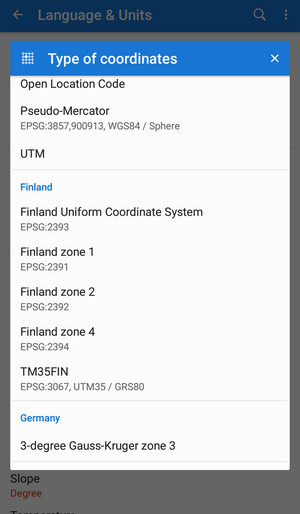
# header from above

1|2391|Finland zone 1|EPSG:2391|Finland
1|2392|Finland zone 2|EPSG:2392|Finland
1|2393|Finland Uniform Coordinate System|EPSG:2393|Finland
1|2394|Finland zone 4|EPSG:2394|Finland
1|3067|TM35FIN|EPSG:3067, UTM35 / GRS80|Finland
1|3857|Pseudo-Mercator|EPSG:3857,900913, WGS84 / Sphere|World
1|31467|3-degree Gauss-Kruger zone 3||Germany
- Save the file and start Locus
- Set new coordinate system in Menu > Settings > Language & Units > Type of coordinates
- the menu will look like this:
Tested coordinate systems Feel free to send us EPSG codes (definitions) that you used, and tested and that worked fine for you.