Translated from English by gtranslate.io
Sidebar
This is an old revision of the document!
Table of Contents
How to work with elevation data in Locus?
Concerns Locus Map Pro only
Elevation data are necessary for many aspects of work with Locus:
- base of calculation of route elevation gain when planning.
- definition of elevation of point objects (POIs, geocaches…)
- database for dynamic elevation tool (displays elevation on the position of the map cursor)
- database for rendering terrain shading
- filling elevation of imported Map items in case the file contains at least one route
- elevation of routes calculated by external navigation engines (BRouter, YOURS, ..)
- elevation gain displayed with guiding lines or lines to GPS location
- database necessary for pressure sensor calibration
- calculation of Trip time
Please do not confuse with current altitude that is obtained from GPS data together with values from the barometric pressure meter in your device (if applicable), see more >>. Current altitude values are also used for calculating elevation gain in recorded tracks and are available also for Locus Map Free users.
Sources
Elevation data can be streamed online or downloaded for offline use. The only advantage of streamed data is their coverage of the seas' and oceans' bottom (underwater depth). Otherwise it consumes your FUP and is slower than displaying downloaded data.
Data for offline use can be downloaded several ways:
LoMaps elevation data
LoMaps cover the whole World. When downloading them from Locus Store, the app offers additional free download of an offline elevation data file (a few extra MBs) for the whole country/state the map covers.
LoMaps elevation data can be downloaded also separately without map data after a LoMap purchase:

Online - creating or editing a point of interest
- Add a new point of interest or open detail screen of an existing point located in the area that we want to cover with elevation data
- find Elevation field and if it is empty, tap the button GET next to it
- Locus Map asks if you want to fill elevation to selected object and download necessary HGT file (from Google)
- select if you want to download it or display online
This method is demonstrated in this tutorial video >>
Online - group of points
- select points (check them) in a desired point folder
- tap
 More and
  Fill elevation in bottom panel
Online - a track
- open a track detail screen
- tap
 More and
  Fill elevation in bottom panel
Elevation data from an external website
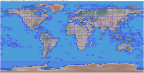
- select area of map shading and download it
- copy the elevation files to Locus/data/srtm directory
Map shading
Map or terrain shading serves better readability of the displayed terrain relief. Locus offers three modes:
- hill shading - simulating covering of the landscape by sun shade
- slopes - highlighting slope gradients of >30°, >35° and >40
- colored elevation - elevation levels are differed by colors (e.g. lowlands are green, mountains brown).
Instructions
Go to Settings > Maps > Advanced > Map shading > Enable (select which type of map should display the shading)
More about map shading settings >>
Is this article useful for you? Please rate it: {(rater>id=1|name=faq_how_to_add_map_shading|type=rate|headline=off)}


