Translated from English by gtranslate.io
Sidebar
manual:user_guide:functions:navigation
This is an old revision of the document!
Table of Contents

Navigation
About
Locus Map provides two kinds of navigation:
- Point-to-point navigation
Standard turn-by-turn navigation with voice orders from point A to point B with route calculated by an external routing service (navigation data source). Locus Map supports several routing services - online or offline. The routing service calculates the route according to selected navigation profile (activity or means of transport) - car, bicycle, foot etc. In case of online routing services it is necessary to maintain the internet connection.Continue >>
- Navigation along a route
Follows user-defined or imported routes. Locus Map renders voice navigation commands automatically from the shape of the route. Continue >>
Navigation Control Panel
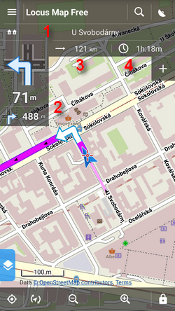 Consists of the street name/road number indicator (1), indicator of the shape and distance of the next two turns (arrow box)(2) and two adjustable fields (3,4) that can display:
- Distance to target (3) (default)
- Time to target (4) (default) - estimated time calculated upon your average speed
- Time of arrival - estimated arrival time calculated upon your average speed
- Time to next junction - time to the next crossroads where the direction will be changed
- Time - device clock
- Altitude - current altitude of the user, calculated from GPS or the device barometer
- Speed - current speed
In some cases the street name/road number indicator may be empty as the navigation source does not have it in its database.
Navigation control menu
Can be displayed by tapping the arrow box.
- topbar contains a shortcut button to navigation settings
- Track - displays track detail window
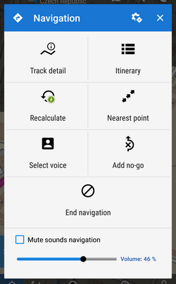
- Itinerary - displays a list of turning points along the route
- Recalculate - manual trigger of route recalculation and indicator of selected navigation profile. Short tap recalculates the route in selected navigation profile. Long tap opens a menu of other available profiles so that the route is recalculated in a different profile.
- Nearest point - shifts the map to the nearest route point
- Select voice - displays a table of installed voices to select from
- End navigation - stops navigation and deletes the calculated route
- Volume slider and Mute check-button - sets volume of voice commands
Navigation Settings
Here you can set your navigation data source, voice commands etc. Continue >>
manual/user_guide/functions/navigation.1477413053.txt.gz · Last modified: 2016/10/25 19:30 (external edit)
Except where otherwise noted, content on this wiki is licensed under the following license: CC Attribution-Share Alike 4.0 International
