Aus dem Englischen übersetzt von gtranslate.io
Benutzertools
Die Seitenleiste
Handbuch:user_guide:maps_wms
Dies ist eine alte Überarbeitung des Dokuments!
Inhaltsverzeichnis

WMS-Karten
Über uns
WMS (Web Map Service) is a standard protocol for serving georeferenced map images over the Internet that are generated by map servers using data from GIS databases. These maps or map data layers are mostly provided by government organizations or education institutions.
WMS can serve almost any type of map. Beginning with topografische Karten, historische Karten, Satelliten- und Luftbilder, Radwege, Stadtpläne, endend mit verschiedenen Datenschichten wie Katasterkarten, Wetterdienste, Umweltschichten, usw.
For more info, read this Wiki-Seite. WMS maps are managed in the WMS tab of Locus map manager.
- This option is fully available only to Premium subscribers.
- Map manager WMS tab can be deactivated (invisible) - to activate it, open
 Aktionsmenü, prüfen Registerkarte WMS anzeigen und Map Manager neu starten
1. Add WMS source
Locus-Karte offers a library of worldwide WMS sources where you can select or you can enter a direct URL to add any WMS source you wish to the app.
Web Services library
- XNUMXh geöffnet WMS-Registerkarte in the Maps Manager
- tippen
 in the lower right corner and select Web Services library:

- Locus Map offers WMS sources verfügbar in Ihrer Nähe entsprechend Ihrer GPS-Position:

- to specify your selection, use Volltextsuche:

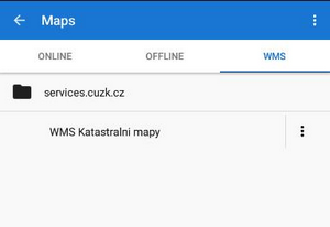
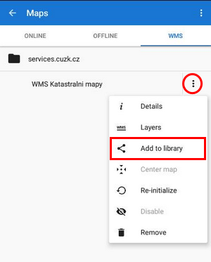
- Tippen Sie auf die ausgewählte Quelle - sie wird hinzugefügt WMS-Registerkarte:
Von Hand eintragen
- wählen Von Hand eintragen von dem menu
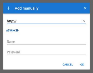
- enter the WMS source address, name or password (if necessary) and press OK
- die Quelle wird hinzugefügt WMS-Registerkarte
- Wenn Sie glauben, dass andere Locus-Benutzer Ihren Link ebenfalls schätzen würden, fragen Sie uns bitte danach fügen Sie es der öffentlichen WMS-Bibliothek hinzu:
Wir testen den Link und nach seiner Validierung wird er der Bibliothek hinzugefügt.
Andere Aktionsmenü Artikel:
- Details - Angaben zur Quelle - Anbieter, Nutzungsbedingungen, Kontakte etc.
- Schichten - Verfügbare Ebenen in der Quelle
- Karte in der Mitte - Richtet die Kartenmitte an der Cursorposition aus, falls sich Ihr tatsächlicher Standort außerhalb der Karte befindet
- Neu initialisieren - lädt die erforderlichen Informationen vom WMS-Server neu und setzt die Karte auf die Standardwerte
- Deaktivieren - blendet ausgewählte WMS-Layer in der Karte aus
- Entfernen - löscht die WMS-Quelle aus der Registerkarte
2. Display WMS map
- Tippen Sie im Kartenmanager auf die ausgewählte WMS-Quelle
- a Liste der verfügbaren Ebenen und ein Deckkraft-Schieberegler erscheint:

- Wählen Sie die anzuzeigenden Ebenen aus, passen Sie ihre Sichtbarkeit über der aktiven Karte an und bestätigen Sie.
- Die WMS-Karte wird angezeigt nur als Overlay über der aktuell aktiven Nicht-WMS-Karte (online oder offline) - nicht als einzelne Karte
- Möglicherweise sind nicht alle WMS-Layer in allen Bereichen und in allen Zoomstufen sichtbar.
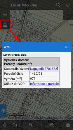
WMS-Controller
Nachdem eine WMS-Karte aktiviert wurde, erscheinen zwei neue Steuerungsschaltflächen in der oberen linken Ecke:

 zeigt das Deckkraft-Schieberegler und Liste der aktiven WMS-Layer wie oben erwähnt - aktivieren oder deaktivieren Sie Layer, die angezeigt oder ausgeblendet werden sollen.
  zeigt a an bestimmte WMS-Funktionsinformationen - Richten Sie die Bildschirmmitte auf ein WMS-Objekt auf der Karte und tippen Sie auf die Schaltfläche. Falls das Objekt zusätzliche Informationen enthält, wird es in einem Popup-Fenster angezeigt:
Die aktuelle WMS-Unterstützung verfügt über keinen Mechanismus für das Caching von Kacheln. Alle Daten werden nur auf Ihrem Gerät gespeichert temporärer Speicher.
Manual/user_guide/maps_wms.1606488794.txt.gz · Letzte Änderung: 2020 11:27 (externe Bearbeitung)
Sofern nicht anders angegeben, ist der Inhalt dieses Wikis unter der folgenden Lizenz lizenziert: CC Namensnennung – Weitergabe unter gleichen Bedingungen 4.0 International
