Aus dem Englischen übersetzt von gtranslate.io
Benutzertools
Die Seitenleiste
Handbuch:user_guide:points:export
Dies ist eine alte Überarbeitung des Dokuments!
Inhaltsverzeichnis

Punkte exportieren
Wozu dient der Export?
Points are exported zu einem anderen Mobiltelefon, zu einer Desktop-Anwendung oder einem Webdienst zur weiteren Verarbeitung - Anzeige in einer anderen Umgebung, Hintergrund, zur Bearbeitung usw.
Anleitung:
1. Select point/s
Einziger Punkt
- Punkte-Manager - select folder > tap the point to open its detail >
 “more options” >
  exportieren

- Kartenbildschirm - tap the point on map > tap its label to open its detail > “more options” > exportieren

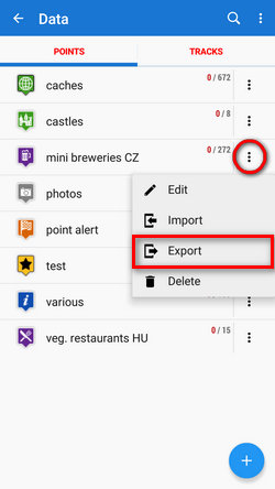
Gruppe von Punkten
- Mehrere Punkte - Points manager > open folder >
 tools > check points you want to export > exportieren

- Whole folder - Points manager > folder
 action menu > exportieren
2. Set parameters and export
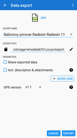
- Exportformat of the file is at the very top of the dialog. By tapping it you can change it into another one:
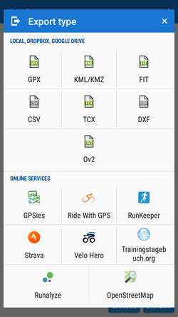
(only file formats can be selected. The dialog is common with the track export so it contains also web services. None of them accepts points)
- Name exportieren - der Name der Exportdatei, normalerweise vorausgefüllt entsprechend dem Punkt-/Ordnernamen. Kann bearbeitet werden.
- Exportpfad - define where to save the exported file. You can select local memory, Dropbox or Google Drive (both apps must be installed first).
- Parameter - change according to selected export format:
 GPX - GPS eXchange-Format is an XML based text format used for handling points, tracks, and routes. Locus fully supports all valid tags. A more detailed description of GPX format is available on this Wikipedia-Seite.
 - Nur Export sichtbar - Exportiert nur Punkte, die tatsächlich auf der Karte sichtbar sind
- Exportierte Daten teilen - enables to share the export file in Dropbox or other services available in your device
- Fügen Sie eine formatierte Beschreibung ein - erstellt a HTML Tabelle mit der Dateibeschreibung – es wird nicht empfohlen, wenn ein erneuter Import oder eine weitere GPX-Bearbeitung geplant ist
- GPX-Version - optionale Einstellung für erfahrene Benutzer von GPS-Geräten
 KML/KMZ - Schlüsselloch-Auszeichnungssprache is XML based plain text format with really wide range of usage. Since the version 2.2 KML format is standardized by OGC so it is used by many web/desktop/mobile applications as well as Locus Map. It is usable for export of both points and tracks.
- parameters identical to GPX export but one:
- Fügen Sie Symbole und Anhänge hinzu - Ermöglicht das Packen von Daten in eine KMZ-Datei - Symbole, Fotos usw.
 CSV - (Comma Separated Values) is a common, universal and relatively simple file format that is widely supported by many applications. Usable for export of both points and tracks. Parameters are just Export visible and Share.
 DXF - (Drawing eXchange Format) - comes from CAD software. Usable for export of both points and tracks. Except of already mentioned parameters it enables to:
- Höhe anzeigen - zeigt die Höhe der exportierten Punkte als Textinformation an
- Echte (3D) Höhe - Verschiebt exportierte Punkte in die tatsächliche Höhe über dem Meeresspiegel und zeigt sie in 3D an
 OV2 - TomTom Format für POI-Datenbank. Dieselben Parameter wie CSV.
Export von Geocaches
Beim Exportieren mehrerer Geocaches in eine GPX-Datei sind alle vorhanden überprüft, ob sie vollständige Informationen enthalten (listing etc.). If they contain just basic info about coords, terrain, difficulty, they are automatisch aktualisiert - Der Export von Geocaches dauert etwas länger als bei gewöhnlichen Punkten.
Wenn Sie diese Aktualisierung vermeiden möchten, stellen Sie Ihr Geocaching4Locus-Addon so ein, dass es alle Informationen zu Caches direkt herunterlädt (Einstellungen > Herunterladen > Deaktivieren Sie „Nur grundlegende Informationen“)
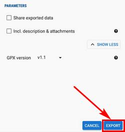
When the parameters are set, just tap the EXPORT button:
Manual/user_guide/points/export.1569839929.txt.gz · Letzte Änderung: 2019 09:30 (externe Bearbeitung)
Sofern nicht anders angegeben, ist der Inhalt dieses Wikis unter der folgenden Lizenz lizenziert: CC Namensnennung – Weitergabe unter gleichen Bedingungen 4.0 International
