Table of Contents
Custom settings
Expert settings
This section is IN CONTINUOUS DEVELOPMENT
Settings that are not essential for running the app and overall user experience. Some of these settings were removed from the general settings because of weak usage, some were found redundant, and some have a purpose only for advanced Locus Map users.
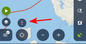
Activation
- long press Locus main menu button
- tap Expert settings
- Expert settings appear at the bottom of the Locus Map general settings
UI/UX
Confirm on exit
It displays/hides a confirmation dialog when you exit the app by double-tapping the back button.
Full screen
This hides system panels. Originally, in the general settings, it was removed as not all devices support this option correctly.
Quick map switch - online
Sets the number of last used online maps (max 20) displayed in the quick map switch menu in the map content panel.
Quick map switch - offline
Sets the number of the closest offline maps (max 20) displayed in the quick map switch menu in the map content panel.
Auto screen-lock
This activates the Locus Map app's screen lock automatically when you switch the screen off.
Panels visible at start
This displays the function and information panels on the screen after the app's start, despite their “hidden” status.
Display tips&tricks
Displays information boxes in various parts of the app, highlighting key features and usage instructions.
Maps
Hold map center timeout
Defines the period of time in seconds before your location is automatically centered on the map screen in case the Hold map center is active.
Enable GPS when centering
Turns the GPS on automatically (if it is disabled) when you tap the centering button. If turned off, the app centers on your latest fixed location.
Dual centering button
Turns on the default button controlling both map centering and rotation. If turned off, two buttons appear on the screen - one for centering and one for rotating the map:
Smooth movement
Animated movement of the cursor during track recording, resulting in a “smooth” shift of the map. Increases the battery consumption a bit due to the high refresh frequency of the screen.
Map movement step
Defines the map shift step in pixels. Used in case the map is controlled by hardware DPAD buttons.
Fill map gaps with other zooms
Allows the use of lower and higher map zooms to cover empty spaces in an actual map zoom. Useful for various custom raster maps.
Crop maps by coverage
With this option, the app takes the map coverage definition into account and stops loading map tiles outside of it. Useful for maps with a non-square shape.
Double tap zoom only
When the Google style for map controlling is on, double-tapping a place on the map zooms in one level and shifts the map slightly towards the tapped place. This option omits the map shift.
Min zoom scale
Here, you can define the minimum allowed scale for zooming the map out. The available range is 10-100% but the values below 50% may cause the app to stop responding.
Automatic zoom lock
This option allows zooming the map in even when no more zoom levels are available - it resizes the lowest map zoom.
Remember last zoom lock
The app remembers the zoom level that you locked last time. When you use the zoom lock next time, the map switches to the locked zoom level you locked before.
Map scale font size
Here, you can define the font size for the map scale label
Show date&time in toolbar
When activated, the top information panel item “time&battery status” also shows time and date.
Map-screen content
Accuracy circle color
Defines the color for the GPS accuracy circle around the location indicator
Settings of auxiliary graphics used on the map screen:
Dynamic elevation color, background, and text size
Defines the style of dynamic elevation digits displayed at the cursor position.
Entries above/below 'Cursor to GPS'
Defines parameters displayed above and below the Cursor to position line - distance, bearing, time of arrival, elevation, time to taget and ETA&time to target.
Cursor to GPS line color, background and text size
Definition of the style of Cursor to position line.
Course line color/background
Definition of the style of the Course line
Heading line color/background
Definition of the style of the Heading line
Time circles color, background, text size
Definition of the style of the Time circles
Distance circles color, background, text size, color/background when no GPS
Definition of the style of the Distance circles
Entries above/below auxiliary lines
Select parameters displayed above and/or below various lines in app - route planner, two-finger measurement, etc. - distance, bearing, time of arrival, elevation, time to target, and ETA&time to target.
Tile hunters grid
Activates the option to select a tile hunter's grid (StatsHunters) in the map content panel grid selection (referring to zoom 14).
Heading without GPS
Enables rotating and displaying the heading line even when the GPS is off.
Map labels
Draw popup labels by zoom
Defines the zooms in which the track/route/point popup labels are displayed. “0” is the default and shows the labels always. “1-22 'include'” defines the zoom range.
Label style
You can set the text color, background, highlighted background, border and highlighted border of a label.
An example of transparent label background:
map_items_labels_color_text=#0A0A0A
map_items_labels_color_bg_normal=#4CF0F0F0
map_items_labels_color_border_normal=#19F0F0F0
map_items_labels_color_bg_highlight=#4CF0F0F0
map_items_labels_color_border_highlight=#19F0F0F0
See the difference (default and customized):


Points
New point name time format
Defines the format of the time used in a new point's name. Default is yyyy-MM-dd HH:mm:ss.
Default icons
You can set the default icon for a new point, waypoint (entered during track recording) and via-point (entered during route planning)
Center on point
By default, the points are centered when tapped, and their detail panel appears. Here you can switch the centering off.
Simplify visible points
Here, you can define the map zoom level from which the point icons are simplified to a dot. The default is 10; 0 means that simplification is turned off.
Tracks & routes
Fill color of ... chart
Custom settings of track/route chart line colors - altitude, cadence, gradient, heart-rate, speed, sensor speed and temperature. The color is defined both for a track/route detail and for dashboards.
Customize altitude threshold
This allows modifying the altitude threshold of all tracks in case the phone's GPS shows deviations or the calculated elevation gain seems exaggerated. When the option is turned on, a new control appears in a track detail edit screen.
Track previews during import
When turned off, the import is a bit faster, especially when you import multiple tracks.
Simplify visible tracks
Defines a map zoom level from which the number of visualized track points is reduced. 22 is the default.
Track selection highlight
When turned on, a track or route tapped on the map is highlighted with a changed color.
Import & export
Width of exported photos
Defines the width of photos attached to points, exported to KML. 60 px is the default.
Navigation/guidance
Auto GPS on navigation
When navigation or guidance is started, the app turns GPS on, although it is turned off.
Guidance path symbol
This parameter allows you to define the shape and size of the guiding line very precisely. Best to explain it on the default parameter.
Basic values are: -8.0|-2.0|7.0|0.0|-8.0|2.0
Imagine a paper with a grid. Each of the two numbers means the X and Y coordinates. So draw them. The result will be as in the picture below. In the same way, you may draw whatever symbol you want.
![]()
Examples:
 guiding_path_symbol=-20|0|-20|-10|0|-10|0|-20|20|0|0|20|0|10|-20|10
 guiding_path_symbol=-11|0|-14|-5|5|0|-14|5
Line/text background color
Allows setting the background color for the guidance line and texts.
Route planner
Route planner - interpolation saving
When turned on, interpolation steps for manual segments are saved within the planned route.
Routeplanner - interpolation step
Definition of distance between interpolated points on route for manual route drawing - affects slope/elevation coloring of the route line. Minimum 1m, recommended 100m.
Geocaching
Offline logging of trackables
Support for logging trackables offline. To log the trackable online, use the log manager in the geocaching tools.
Hardware controlling
Hardware buttons over 'screen lock'
When enabled, hardware buttons can control the app even when the screen is locked.
Scroll to zoom
When enabled, it is possible to zoom the map by a scrolling controller (e.g. mouse when running on a PC)
In this section, also KEY-CODEs for various events can be configured: Screen on/off, GPS on/off, Map centering on/off, Map rotation on/off, Map zoom in/out and Screen lock toggle.
Tools
GPS auto-off
A system for turning the GPS off automatically to save battery consumption, e.g., during long-distance hikes.
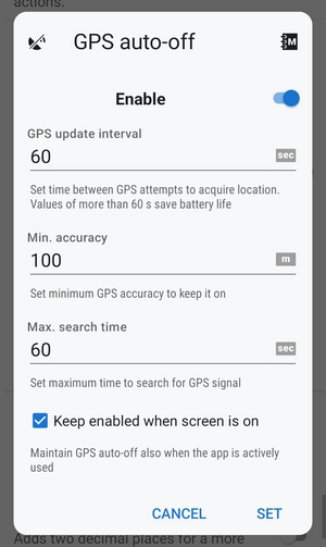
- GPS update interval - sets the time interval of GPS switching on and locating the device. Values of more than 60 seconds save battery life.
- Min accuracy - sets the minimum GPS locating accuracy to keep GPS on. When the accuracy is lower due to too few detectable satellites, the GPS turns off.
- Max search time - sets the maximum time of GPS signal searching. If the GPS fix is not secured within this period, the GPS turns off.
- Keep auto-off enabled - keeps GPS auto-off enabled even if Locus Map is active and the screen is on.
This option is not available/reliable on devices running OS Android 12+ due to the system restrictions of certain automatic actions running in the background.
Notify of disabled GPS
When turned on, the app notifies when the system's GPS is switched off.
Enable online search (old)
Adds the obsolete online search based on the Google Places service to the offer of search methods.
Record sensors data
When enabled, all the phone sensors' data are recorded in a file in the Locus/data/sensors directory.
Units
Coordinates, high precision
Adds two decimal places to the coordinate values. Useful when a sub-meter external GNSS unit is connected.
Altitude, high precision
Adds two decimal places to the altitude values. Useful when a sub-meter external GNSS unit is connected.
Angle, high precision
Adds two decimal places to the angle and gradient values.
Tweaks
Hardware acceleration
Turn on to accelerate rendering of points and tracks on the map.
Login over Google Play Services
When switched off, only an email login to Locus Store or Live Tracking is possible. Recommended when MicroG service is used. Deactivating results in logging you out of your Locus account.
Set a custom camera app
Enables the use of any installed custom camera app for use within Locus Map. Just insert its package name.
Set a translation app
Select from the system chooser or installed translation apps.
Development
These options are for development only and are considered risky for ordinary app usage.
Log to file
App records all its processes into logs in the Locus/logs directory.
Draw map tile bounds
Displays map tile bounds, including related information above the map.
WakeLock when GPS on
Keeps partial wakelock enabled while using GPS.
Configuration file
- Locus Map offers advanced configuration options through config.cfg file stored in Locus Map root directory
- This file is automatically created at the Locus Map first start (if it does not exist from its previous installation). Data is loaded on app start and stored back to the file when the app is closed, so even if this file allows changing some settings that are also changeable in the application, the settings won't be lost.
As this method has become obsolete and is quite user-unfriendly, settings included in this configuration file are moved gradually to the Expert settings section mentioned above.