Translated from English by gtranslate.io
Sidebar
manual:user_guide:geocaching:tools
This is an old revision of the document!
Table of Contents

Geocaching Tools
About
Menu > More functions > Geocaching tools
Geocaching tools contain many useful options for some special geocaching cases:
- Graphic computations - for better solving some of mystery caches
- 161 m circles around caches - to secure a correct radius from another cache when creating a new one. More about this see here >>
- Already created field notes check and login
- etc.
Geocaching LIVE!
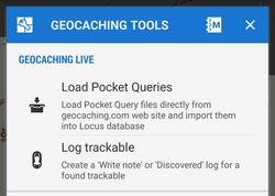
- Load Pocket Queries - see Pocket Queries in Import chapter. This option is available only to Locus Map Pro users
- Log trackable - enables logging found trackable item directly from the app (internet connection required). This option is available only to Locus Map Pro users. More about trackables >>
Geocaching tools
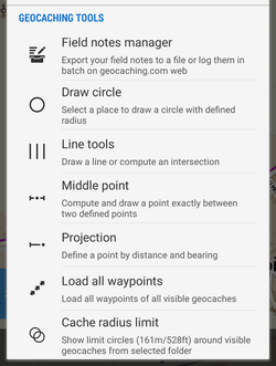
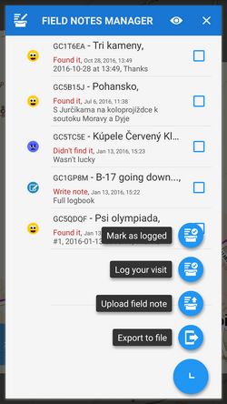
- Logs manager - Locus Map can log your geocaches offline in drafts (field notes) that can be logged online later. This is the place where the drafts (field notes) can be simply managed, e.g. exported in a file or logged in Geocaching.com website.
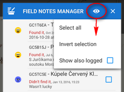
You can control which drafts you want to visualize in the topbar menu:
For advanced geocachers who want to filter, sort or batch-edit drafts we strongly recommend the FieldNotes Add-on.
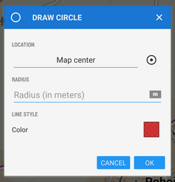
- Draw circle - draws a circle with defined radius and color/opacity around any selected place on the map
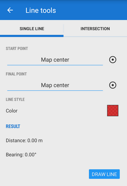
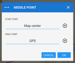
- Line tools - draws a line between two defined coordinates or calculates an intersection point of two lines
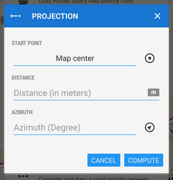
- Projection - calculates a new point from its distance and azimuth from your location and draws it on the map. This function is available also in Location selector.
- Load all waypoints - displays all waypoints of visible geocaches on the map
- Cache radius limit - according to Geocaching.com rules, physical parts of individual geocaches may be placed at least 528ft/161m from each other. This function helps visualize such area. Locus asks which geocaches you want to highlight and offers your folder structure.
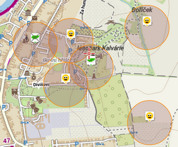
To remove the circles, turn this feature on and re-select the same cache folder. More about geocaching guidelines here >>
How to remove items drawn by the geocaching tools:
- tap the
 Hide temp map items button in Map items screen topbar or
 - long-tap the Data manager button in the Function panel and select Hide temp map items or
- add Hide temp map items button directly to your Function panel
![]()
Geocaching offlinizer
 Available only in Locus Map Pro version
Geocaching Offlinizer is abbreviation of a more accurate Geocaching Image Offlinizer. The feature is not among other geocaching tools but can be found in a Geocache detail screen under side geocaching menu or, in case of selecting more caches, in the tools menu in the bottom bar of the point manager. To make it work follow these instructions:
- in Geocache Folder select caches you want to “offlinize”
- choose GC Offlinizer from the tools menu and a new dialog pops
- if you just want to download images that are included in cache listings do not check Live API. It is also much faster.
- if you need also spoilers or you are not sure if listings are complete or contain links to all images, use Live API. This action requires valid Geocaching Live login.
- if you just want to download spoilers, you have to use Live API and check Only spoilers.
Data storage
- all downloaded images are stored in Locus/data/geocaching directory
- a new tab Images is added to Geocache Detail screen, containing all downloaded images of the cache
It is recommended to clear unused images (that remain in your phone memory when you delete caches from Locus database) from time to time. Go to Settings > Miscellaneous > Clear temporary data and select Unneeded geocaching data or Unused attachments.
manual/user_guide/geocaching/tools.1536231598.txt.gz · Last modified: 2018/09/06 12:59 by 127.0.0.1
Except where otherwise noted, content on this wiki is licensed under the following license: CC Attribution-Share Alike 4.0 International
