Translated from English by gtranslate.io
Sidebar
manual:user_guide:maps_tools:overlays
Table of Contents

Map Overlays
About
This feature enables laying two maps over each other in a semi-transparent mode so that it is possible to compare their details, coverage, accuracy etc. or two maps can complement each other.
Available only with Premium
1. Select your base map
Choose from your Map manager:
- Online maps - all
- Offline maps - vector maps (.MAP format), MBT, GEMF and some SQLite databases (Orux SQLite and other formats are not supported)
2. Select your overlay map
- Open the Content panel and tap Map overlays.
- Activate the overlay

- The last used overlay map is activated. If you want to use another one, open the selection of the last used maps. The link to the map manager is included:
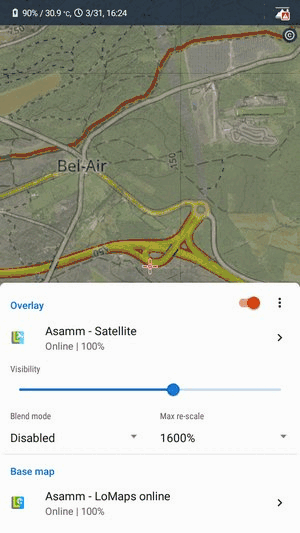
3. Set transparency and blend mode
- Adjust transparency of the overlayed map:

- The blend mode of the two maps is disabled by default - in most cases, it is not necessary to change this. If necessary, select one from the menu - try which one suits you the best. More about blend modes used in Locus map >>. Here are a few examples:

- Max re-scale - maximum allowed rate for the map resolution change
Deactivation
Turn the overlay switch off or just tap the eye button on the content panel:

Example
LoMaps center of Prague with and without satellite image map overlay:


manual/user_guide/maps_tools/overlays.txt · Last modified: 2023/07/14 13:44 by mstupka
Except where otherwise noted, content on this wiki is licensed under the following license: CC Attribution-Share Alike 4.0 International
