Translated from English by gtranslate.io
Sidebar
manual:user_guide:tracks:export
Table of Contents

Export of Tracks and Routes
What is export for?
Tracks and routes are exported to another device, to a desktop application or web service for further processing - displaying in a different environment, navigation, for editing, etc.
1. Select what to export
Single track/route
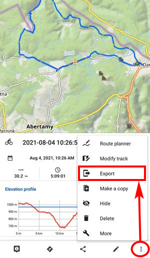
- Tap it on the map or in the Tracks&route manager > folder
- Open
 menu in the detail panel >
  export
Multiple tracks/routes selection
- Open the Track&route manager > folder > tools
- check tracks/routes for export > export

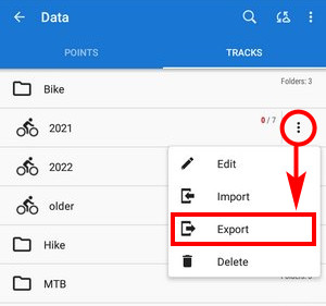
Folder with tracks/routes
- Open the Track&route manager
- Select the folder >menu > export
2. Set it up
- Export type - indicates the selected format or service. Tap it to open the selection of other formats and services:

- Export title - date/time stamp of creating the track is the default. You can change it as you need.
- Export path - defines the path where the exported file will be saved. Either it is pre-set or you can change it - select among the device storage, Dropbox, Google Drive, or OneDrive.
- Parameters - change according to selected export format (see further)
3. Export
Tap the EXPORT button:

Supported export formats
 GPX - GPS eXchange format is an XML based text format used for handling points, single tracks, multiple tracks and routes. Locus fully supports all valid tags. More detailed description of GPX format is available on this Wikipedia page.
 - Export only visible - the checkbox is active only when exporting a whole folder with tracks. Checking it exports only tracks actually visible on the map
- Share exported data - enables you to share the export file in Dropbox or another service available on your device
- Incl. description and attachments - adds icons, generated descriptions, photos and other attachments and exports them into a detached subfolder
- Track to route - TRK tags in the file will be replaced by RTE tags so that the file can be used as a route for navigation in external devices
- Inlude navigation commands - exported file contains turn-by-turn voice navigation commands
- GPX version - optional setting for experienced GPS device users
 KML/KMZ - Keyhole Markup Language is XML based plain text format with really wide range of usage. Since the version 2.2 KML format is standardized by OGC so it is used by many web/desktop/mobile applications as well as Locus Map. It is usable for export of both points and tracks including multiple tracks.
- parameters identical to GPX export except the option to turn tracks into routes
- Include icons and attachments - adds icons, generated descriptions, photos and other attachments and packs them into one KMZ file
 TCX - Training Center XML is a data exchange format introduced as part of Garmin's Training Center product. The XML is similar to GPX since it exports GPS tracks, but treats a track as an Activity rather than simply a series of GPS points. TCX provides standards for transferring heart rate, running cadence, bicycle cadence, and calories in the detailed track. It also provides summary data in the form of laps. The format does not support multiple tracks export. Locus provides two export modes - as Activity (suitable for uploading at Garmin Connect website and as Course (just basic info about the track). The exported file can be shared directly.
- FIT - another Garmin format with the same modes as TCX - activity and course
 CSV - (Comma Separated Values) is a common, universal and relatively simple file format that is widely supported by many applications. Usable for export of both points and single tracks. The only parameter is Share option.
 DXF - (Drawing eXchange Format) - comes from CAD software. Usable for export of points, tracks and multiple tracks. Except of already mentioned parameters it enables to:
- Real (3D) altitude - moves exported tracks into real height above the sea level and displays them in 3D
Supported online services
All supported online services need their designated user login and password!
 Ride With GPS - complete software solution for cyclists. Send the GPX file to upload@rwgps.com from the email address associated with your account and it will be processed automatically.
 Runkeeper - one of the most used web/mobile sport trackers. More than 30 million people around the world use RunKeeper to power their active lives. It tracks your workouts and gives the motivation you need to hit your fitness goals.
- Export parameters:
- Activity - wide selection of track activities
- Post to Facebook - renders a post to user's Facebook about the exported track
- Post to Twitter - renders a post to user's Twitter about the exported track
- Automatically detect and insert pause points - surveys the track for spots with zero speed, marks them and subtracts them from total track time
 Strava - another sport tracker/social network. Strava lets you track your rides and runs via your iPhone, Android or dedicated GPS device, helps you analyze and quantify your performance and offers comparison and competition with other members.
 - Export parameters:
- Activity - selection of activities
- Preserve measured altitude - otherwise offers 3D model altitude (less accurate)
- Commute - checking no-sports activity for excluding from training statistics
 Velo Hero - a free and vendor-independent training log and performance analysis software, that gives competitive cyclists the motivation and support to achieve their athletic goals. Runners and triathletes are welcome, too.
- Activity - selects activity on your track
 Trainingstagebuch.org - German free and vendor-neutral training platform that gives you the motivation and support to achieve your athletic goals! Over 45,000 athletes already manage over 2.5 million sessions at Trainingstagebuch.org and it is growing every day.
 Runalyze - training analysis for runners, triathletes bikers, rowers - by athletes for athletes. Statistics, prognoses and more.
 OpenStreetMap - export of tracks into this service serves the purpose of updating OS maps. Public visibility of tracks can be configured in 4 options:
- identifiable - other users will be able to download the track and identify it with your username
- public - other users will be able to download the track without identification
- trackable - the track will not show up in any public listings but its track points will be available through the public GPS API with timestamps
- private - the track will not show up in any public listings but its track points will be available through the public GPS API without timestamps

Additional settings
- Menu > Settings > Miscellaneous > Import & export
manual/user_guide/tracks/export.txt · Last modified: 2023/07/14 11:37 by mstupka
Except where otherwise noted, content on this wiki is licensed under the following license: CC Attribution-Share Alike 4.0 International
