Traduit de l'anglais par gtranslate.io
Outils utilisateur
Sidebar
manuel:guide_utilisateur:points:locus_maps_pois
Il s'agit d'une ancienne révision du document !
Table des matières

LoPoints
page in maintenance
A Propos
LoPoints sont des points d'intérêt dynamiques qui peuvent être affichés au-dessus de n'importe quelle carte. Chaque LoPoint marque l'emplacement et la catégorie d'un lieu particulier et contient des informations supplémentaires - par exemple les heures d'ouverture, le WWW, le numéro de téléphone et d'autres attributs. Les LoPoints peuvent être navigués et guidés de la même manière que les points utilisateur Locus. Les LoPoints sont basés sur les données OpenStreetMap et Wikipedia.
Online LoPoints are streamed from the internet and contain also photos from Wikipedia and from Locus users.
Hors ligne
Les LoPoints hors ligne sont un partie intégrante de LoMaps but can be displayed above any other map.
Parcourir
Offline LoPoints can be also parcouru by categories and highlighted on the map.
- barre du haut
 - when particular points are selected, the button changes and displays a number of them on the map. Tapping this removes highlighting of choisi points sur la carte.
 - with this, TOUTE LoMaps POIs on the map can be displayed or hidden
- Fichier LoMaps - select a file with the POI database. It is identical to the LoMaps file. It is possible to select one file only.
- Points autour - displays a list of all nearest points across all folders around your current position or position of the center cursor
- Rechercher - full-text search of POI. Entering the first few characters returns results that can be further refined.
- list of POI categories - Accommodation, Financial&Post services, Culture&Tourism, Public services, Hiking&Cycling, Nature, Emergency&Health, Places of Worship, Food&Drink, Shopping, Sport leisure, Car services, Transportation

Parcourir
LoPoints database consists of several catégories, par exemple Accommodation, Financial&Post services, Culture&Tourism etc. Each category is sub-divided into subcategories and also contains a special parameter “autour” that allows browsing points around the current location of the user.
Points in a selected category can be highlighted on map en tapotant ![]() in topbar (showing also number of points in the selected category):
in topbar (showing also number of points in the selected category):
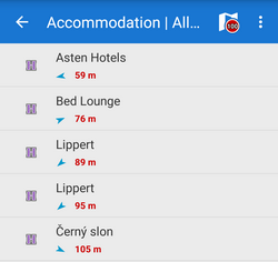
When you tap a particular point its detail info screen opens. All points in categories are always sorted by distance from the map screen cursor (or from the user's location if the device is GPS fixed and the map centered).
It is not possible to export LoPoints. Only a highlighted display is allowed.
Rechercher
Full-text search of names and keywords. E.g. keyword “pub” returns all points with “pub” in their name, description or amenity. 
Désactivation
LoPoints can be deactivated - hidden on the map. Robinet ![]() in the topbar and décochez Afficher sur la carte.
in the topbar and décochez Afficher sur la carte. 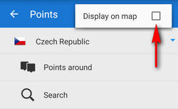
LoPoints database (mapname.osm.db) can be used only when a corresponding LoMap map file (mapname.osm.map) is present in /mapsVector/ directory. If the map file is removed (e.g. due to saving space for use of other map) the POI file cannot be initialized.
manuel/user_guide/points/locus_maps_pois.1655297133.txt.gz · Dernière modification : 2022/06/15 14:45 par mstupka
Sauf indication contraire, le contenu de ce wiki est sous la licence suivante : CC Attribution-Partage dans les mêmes conditions 4.0 International
