Traduit de l'anglais par gtranslate.io
Outils utilisateur
Sidebar
manual:user_guide:fonctions:guide
Il s'agit d'une ancienne révision du document !
Table des matières

Accompagnement
 RECONSTRUCTION
Guidance To a Point
Hors route, guidage en ligne droite vers un lieu sélectionné, indépendant du réseau routier. Utilisé notamment pour l'orientation en terrain libre.
Généralement utile pour trouver géocaches ou se dirigeant vers user point of interest ainsi que POI LoMap (remote viewpoint, waterfall etc.)
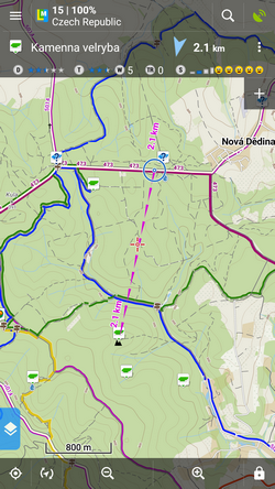
How to start guidance? Select target and start guiding to it.
Sélection cible
A particular point on map
- tap the point on map
- exploiter
 et alors
  Guide activé:
gif
Lieu indéterminé sur la carte
- long-tap a place on map
- une fenêtre contextuelle (généralement avec une adresse) apparaît
- exploiter et alors Guide activé:
gif
Dans le gestionnaire de points
- aller à la Menu > Points > folder > tap the selected point and open its detail screen
- exploiter
 in the bottom panel and select Guide activé
Point guidance control panel
When you start guiding to a point a special control panel appears at the top of the screen. It displays information about the point, its distance and direction. In case of guidance to a geocache there are also other facts like the cache type, difficulty and terrain. Tapping the panel displays the point detail screen. The context menu on the right side of the panel contains following:
- Point detail - opens the point detail screen too
- Astuce - en cas de guidage vers une géocache
- Charger tous les waypoints - en cas de guidage vers une géocache
- Accédez à - switches to turn-by-turn navigation and calculates route
- Guide désactivé - arrête le guidage
- Compas - passe en boussole view and guidance
- Cacher - rend le point invisible sur la carte

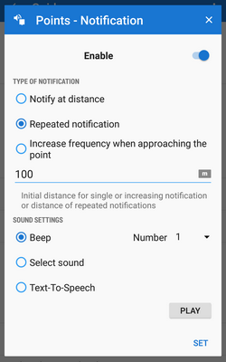
Guidance notifications
 Locus Map can notify you when you reach defined distance from the point of guidance, repeat and even increase frequency of the alerts when getting nearer.
- Menu > Paramètres > Guidage > Notification
- Interrupteur Notification on
- Select notification mode:
- Notify at distance - Locus alerts you once when you reach defined distance
- Repeated notification - Locus alerts you repeatedly in defined distance intervals
- Increase frequency when approaching the point - Locus alerts with repeated beeps with increased frequency
- Met le distance you want to be alerted at (or distance interval between repeated notifications). When the first two options are selected, there are further settings:
- Paramètres de son
- Désactiver - tous les sons sont désactivés, la notification est faite par l'écran de l'appareil et le vibreur uniquement
- Bip - notification by a beeping sound. It is possible to set number of beeps (1-10)
- Sélectionnez le son - sélectionnez n'importe quel son stocké dans la mémoire de votre appareil
- Texte pour parler - voice notification informing about distance and direction of the point
Exploiter Jouez pour vérifier vos paramètres de son.
- Paramètres de vibration - visible uniquement lorsque l'appareil est équipé d'un vibreur (téléphones portables principalement)
- Désactiver - l'appareil ne vibre pas sur les notifications
- Patron de Couture - sets notification vibrating pattern, using three symbols: '.' for 200 miliseconds vibration, '-' for 500 miliseconds vibration and ' ' (space) for 500 miliseconds of silence.
Exploiter Jouez pour vérifier vos paramètres de vibration.
Auto-zooming according to distance from the point
Locus peut agrandir la carte automatiquement en fonction de la distance du point you are guided to - the closer the target is the bigger zoom is displayed. The option can be switched on in Settings > Maps advanced > Miscellaneous > check Speed Auto-zoom.
Dans un premier temps, la fonction effectue un zoom en fonction de votre vitesse actuelle, en commençant à 2000 XNUMX m de la cible, elle passe au mode de zoom basé sur la distance. Applicable uniquement pour le guidage vers un point (pas le long d'un itinéraire).
Guidage le long d'un itinéraire
Technically, guidance along a route is actually guidance to a chain of trackpoints. You are guided to the first point of the route, then to the second etc. It is useful e.g. for sailing, sea-kayaking, flying or crosscountry hiking when there are no roads for turn-by-turn navigation. Nevertheless, Locus Map can help you with orientation by screen and sound alerts at important track turns.
- Menu (or top panel > Data manager) > Tracks tab
- tap the selected track to display the detail screen
- bottom panel >
 Navigation/guidance button >
 Guidance (check Guide reversely if you need reverse guiding)
 - a line with the indicator of distance stretches between your position and the starting point
- direction-change waypoints emerge on the route line
- an additional upper bar emerges
Alternatively the guidance can be started by selecting the track directly on map if it is visible, tapping the arrow button and selecting Navigation/guidance > Guidance.
- La carte du lieu peut alert you of the next direction change (Si vous mettre en place) by a sound signal and switching the display on (must be préréglée ainsi que).
Route guidance control bar
- Bouton de guidage

- d'information - detail info on the track
- point le plus proche - guidance to the nearest point of the track (it does not have to be the starting point)
- point suivant - guidance to the nearest trackpoint of the previous one
- guider - aborts the guidance
- two optional fields - tapping them unfolds a menu of features to display:
- Distance à la cible (Par défaut)
- Il est temps de cibler - temps estimé calculé sur votre vitesse moyenne
- Heure d'arrivée - heure d'arrivée estimée calculée sur votre vitesse moyenne
- Nom du prochain waypoint - dans le cas où les waypoints sont nommés
- Distance jusqu'au prochain waypoint
- Temps jusqu'au prochain waypoint - estimated time calculated according to current speed
- Temps - horloge de l'appareil
- Altitude - altitude actuelle de l'utilisateur, calculée à partir du GPS ou du baromètre de l'appareil
- Vitesse
manuel/user_guide/functions/guidance.1542897502.txt.gz · Dernière modification : 2018/11/22 16:38 (édition externe)
Sauf indication contraire, le contenu de ce wiki est sous la licence suivante : CC Attribution-Partage dans les mêmes conditions 4.0 International
