

Translated from English by gtranslate.io
Settings that are not essential for running the app and overall user experience. Some of these settings were removed from the general settings because of weak usage, some were found redundant, and some have a purpose only for advanced Locus Map users.
It displays/hides a confirmation dialog when you exit the app by double-tapping the back button.
This hides system panels. Originally, in the general settings, it was removed as not all devices support this option correctly.
Sets the number of last used online maps (max 20) displayed in the quick map switch menu in the map content panel.
Sets the number of the closest offline maps (max 20) displayed in the quick map switch menu in the map content panel.
This activates the Locus Map app's screen lock automatically when you switch the screen off.
This displays the function and information panels on the screen after the app's start, despite their “hidden” status.
Displays information boxes in various parts of the app, highlighting key features and usage instructions.
Normally, the GPS and Compass share the same double-tabbed screen. By turning this on, you assign an individual screen for each feature. Useful if you have a low-powered device.
By default, the Compass screen is black. By turning this on, you change the color to shades of white.
Automatically closes the Quick add point dialog after a new point is added.
The app can serve the map currently displayed on the main screen to nearby devices sharing the same network. The Locus Map web is the most obvious recipient.
Supported zoom levels are displayed for each map in the list of online maps.
Defines the period of time in seconds before your location is automatically centered on the map screen in case the Hold map center is active.
Turns the GPS on automatically (if it is disabled) when you tap the centering button. If turned off, the app centers on your latest fixed location.
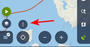
Turns on the default button controlling both map centering and rotation. If turned off, two buttons appear on the screen - one for centering and one for rotating the map:
Animated movement of the cursor during track recording, resulting in a “smooth” shift of the map. Increases the battery consumption a bit due to the high refresh frequency of the screen.
Defines the map shift step in pixels. Used in case the map is controlled by hardware DPAD buttons.
Allows the use of lower and higher map zooms to cover empty spaces in an actual map zoom. Useful for various custom raster maps.
With this option, the app takes the map coverage definition into account and stops loading map tiles outside of it. Useful for maps with a non-square shape.
When the Google style for map controlling is on, double-tapping a place on the map zooms in one level and shifts the map slightly towards the tapped place. This option omits the map shift.
Here, you can define the minimum allowed scale for zooming the map out. The available range is 10-100% but the values below 50% may cause the app to stop responding.
This option allows zooming the map in even when no more zoom levels are available - it resizes the lowest map zoom.
The app remembers the zoom level that you locked last time. When you use the zoom lock next time, the map switches to the locked zoom level you locked before.
Here, you can define the font size for the map scale label
When activated, the top information panel item “time&battery status” also shows time and date.
Defines the color for the GPS accuracy circle around the location indicator
Settings of auxiliary graphics used on the map screen:
Defines the style of dynamic elevation digits displayed at the cursor position.
Defines parameters displayed above and below the Cursor to position line - distance, bearing, time of arrival, elevation, time to taget and ETA&time to target.
Definition of the style of Cursor to position line.
Definition of the style of the Course line
Definition of the style of the Heading line
Definition of the style of the Time circles
Definition of the style of the Distance circles
Select parameters displayed above and/or below various lines in app - route planner, two-finger measurement, etc. - distance, bearing, time of arrival, elevation, time to target, and ETA&time to target.
Activates the option to select a tile hunter's grid (StatsHunters) in the map content panel grid selection (referring to zoom 14).
Enables rotating and displaying the heading line and 'Show view' even when the GPS is off.
Defines the zooms in which the track/route/point popup labels are displayed. “0” is the default and shows the labels always. “1-22 'include'” defines the zoom range.
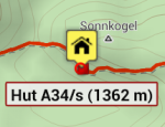
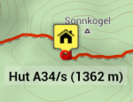
You can set the text color, background, highlighted background, border, and highlighted border of a label.
An example of a customized map label:
Defines the format of the time used in a new point's name. Default is yyyy-MM-dd HH:mm:ss.
Date/time format for the {t} tag in the Quick add point feature (default: yyyy-MM-dd 'at' HH:mm).
You can set the default icon for a new point, waypoint (entered during track recording) and via-point (entered during route planning)
By default, the points are centered when tapped, and their detail panel appears. Here you can switch the centering off.
When you move a point from a folder to a different folder in your Library, the point will be hidden from the map.
Here, you can define the map zoom level from which the point icons are simplified to a dot. The default is 10; 0 means that simplification is turned off.
This allows modifying the altitude threshold of all tracks in case the phone's GPS shows deviations or the calculated elevation gain seems exaggerated. When the option is turned on, a new control appears in a track detail edit screen.
When turned off, the import is a bit faster, especially when you import multiple tracks.
Defines a map zoom level from which the number of visualized track points is reduced. 22 is the default.
When turned on, a track or route tapped on the map is highlighted with a changed color.
When turned on, a short beep is played on each successfully recorded track point.
Displays a box with the measured area covered by the track in the track stats.
Defines the width of photos attached to points, exported to KML. 60 px is the default.
When you export multiple items in one file, it is also compressed into a ZIP archive.
Here, you can define pipe-separated folder names whose points are always overwritten when importing duplicates, e.g. favorites|geocaching.
When navigation or guidance is started, the app turns GPS on, although it is turned off.
Here you can set the time in seconds when the navigation commands are announced before a turn. Enter pipe-separated values. The default is 15|35|300.
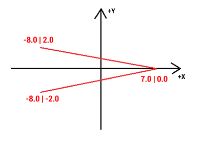
This parameter allows you to define the shape and size of the guiding line very precisely. Best to explain it on the default parameter.
Basic values are: -8.0|-2.0|7.0|0.0|-8.0|2.0
Imagine a paper with a grid. Each of the two numbers means the X and Y coordinates. So draw them. The result will be as in the picture below. In the same way, you may draw whatever symbol you want.
Examples:
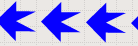 guiding_path_symbol=-20|0|-20|-10|0|-10|0|-20|20|0|0|20|0|10|-20|10
 guiding_path_symbol=-11|0|-14|-5|5|0|-14|5
Allows setting the background color for the guidance line and texts.
When turned on, interpolation steps for manual segments are saved within the planned route.
Definition of distance between interpolated points on route for manual route drawing - affects slope/elevation coloring of the route line. Minimum 1m, recommended 100m.
Support for logging trackables offline. To log the trackable online, use the log manager in the geocaching tools.
Here you can define the maximum size of a single image downloaded by the GC offlinizer.
Draws thin lines between a geocache and its waypoints on the map.
Set the width of the cache - waypoint lines in dp (1 dp is the default).
Define the zoom limit above which the GC waypoints are hidden. Zoom 12 is the default.
When a custom GC icon pack is available, it displays here in the list.
When enabled, hardware buttons can control the app even when the screen is locked.
When enabled, it is possible to zoom the map by a scrolling controller (e.g. mouse when running on a PC)
In this section, the keys for various events can also be configured: Screen on/off, GPS on/off, Map centering on/off, Map rotation on/off, Map zoom in/out and Screen lock toggle - press a hardware button to map it for each action comfortably.
Define a degree offset to apply to the raw hardware compass reading to correct possible misalignment.
Adjust the smoothing factr for the hardware compass sensor (1 = no smoothing, 50 = max smoothing, 10 = default)
A system for turning the GPS off automatically to save battery consumption, e.g., during long-distance hikes.
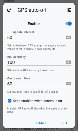
This option is not available/reliable on devices running OS Android 12+ due to the system restrictions of certain automatic actions running in the background.
When turned on, the app notifies when the system's GPS is switched off.
A “hack” attempting to keep GPS and the app running in the background despite the system battery optimization. Only partly functional.
When turned on, the app saves each day's NMEA data as a separate incremented file instead of one continuous file.
Useful for the app testing - simulated speed in m/s is applied to the map cursor when GPS is off. 0 = disabled.
Here you can set a maximum duration for sound and song notifications (default: 5s. 0s = unlimited)
When enabled, compass orientation is controlled by Settings > Compass. When disabled, the internal device orientation sensor is always used.
When the screen is turned on by a proximity gesture, disable the automatic turn off if the timer is idle.
Adds the obsolete online search based on Google Places and other 3-rd party services to the offer of search methods.
When enabled, all the phone sensors' data are recorded in a file in the Locus/data/sensors directory.
Adds two decimal places to the coordinate values. Useful when a sub-meter external GNSS unit is connected.
Adds two decimal places to the altitude, angle, distance and gradient values.
Reduces computation o very long geodetic lines to prevent rare crashes on some devices.
Turn on to accelerate rendering of points and tracks on the map.
When switched off, only an email login to Locus Store or Live Tracking is possible. Recommended when MicroG service is used. Deactivating results in logging you out of your Locus account.
Enables the use of any installed custom camera app for use within Locus Map. Just insert its package name. You can find it in the URL of the Google Play page of the app:

Select from the system chooser or installed translation apps.


