Table of Contents

Geocaching Tools
Menu > All features > Geocaching > Geocaching tools
Geocaching LIVE!
Available only with Locus Map Premium
The first use of these tools triggers logging in to the Geocaching.com website and permission to share its data with Locus Map.
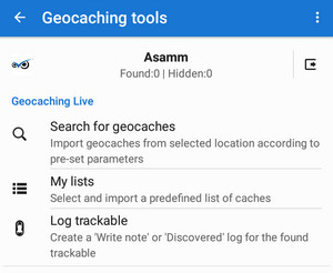
Search for geocaches
Imports geocaches from the Geocaching.com website according to the selected location and other parameters. More here >>
My lists & PQ
This loads Lists and Pocket Queries defined on your geocaching account page. More here >>
Log trackable
Enables logging found trackable items (internet connection required). More about trackables >>
Geocaching tools

Logs manager
Locus Map can log your geocaches online or offline in drafts (field notes) that can be logged online later.
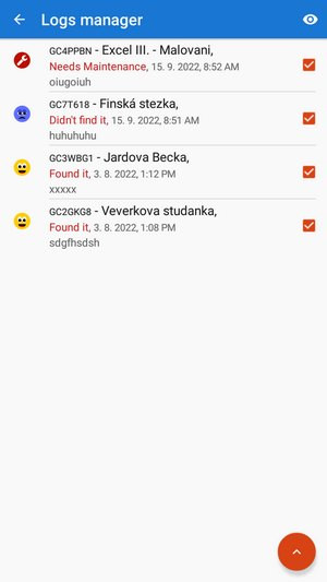 This is the place where the drafts (field notes) can be simply managed, e.g. exported in a file or logged into the Geocaching.com website.

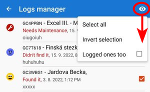
You can control which drafts you want to visualize in the topbar menu:
Draw circle
Draws a circle with a defined radius and color/opacity around a selected place on the map

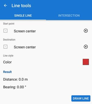
Line tools
Draws a line between two defined coordinates or calculates an intersection point of two lines
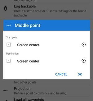
Middle point
Sets location of two points and calculates exact center between them
Projection
Calculates a new point from its distance and azimuth from your location and draws it on the map. This function is available also in Location selector.

Load all waypoints
Displays all waypoints of geocaches activated on the map
Geocache radius limit
According to Geocaching.com rules, physical parts of individual geocaches may be placed at least 528ft/161m from each other. This function helps visualize such an area. Locus asks which geocaches you want to highlight and offers your folder structure.

To remove the circles, turn this feature on and re-select the same cache folder. More about geocaching guidelines here >>
How to remove items drawn by the geocaching tools:
- tap the
 Clear map screen button in Map items screen topbar or
 - long-tap My library button in the Function panel and select Clear map screen or
- add Clear map screen button directly to your Function panel
![]()
Geocaching offlinizer
Available only with Locus Map Premium
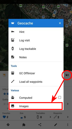
Geocaching offlinizer is an abbreviation of a more accurate Geocaching image offlinizer. The feature is not among other geocaching tools. Still, it can be found in a Geocache detail panel under context menu or, in case of selecting more caches, in the tools menu in the bottom bar of the point manager. To make it work, follow these instructions:
- in the geocache folder, select caches you want to “offlinize”
- choose GC Offlinizer from the tools menu and a new dialog pops up
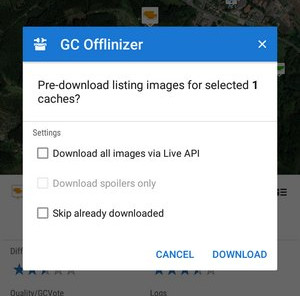
- if you just want to download images that are included in cache listings do not check Live API. It is also much faster.
- if you need also spoilers or you are not sure if listings are complete or contain links to all images, use Live API. This action requires a valid Geocaching Live login.
- if you just want to download spoilers, you must use Live API and check Only spoilers.
Data storage
- all downloaded images are stored in Locus/data/geocaching directory
It is recommended to clear unused images (that remain in your phone memory when you delete caches from the Locus database) from time to time. Go to Settings > Miscellaneous > Clear temporary data and select Unneeded geocaching data or Unused attachments.