Translated from English by gtranslate.io
Sidebar
manual:user_guide:functions:navigation:settings
This is an old revision of the document!
Table of Contents

Navigation Settings
Router
Here you can set up the default service for calculating routes for Navigate to feature and the Route planner. Locus has its own service LoRouter but it can also cooperate with external routers. Each service has specific properties, some are functional online only, and some work offline (after downloading offline navigation data).

LoRouter Online
Online LoRouter offers 8 routing profiles:
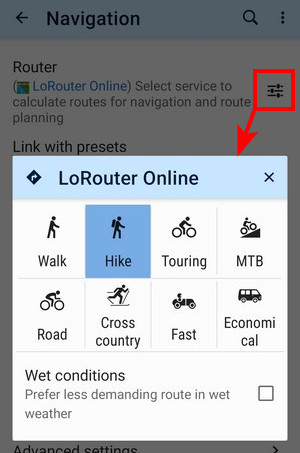
Some of the profiles contain additional customization options:

Furthermore, the MTB profile offers a selection of the terrain level in 5 degrees from smooth to rugged for fine-tuning of the route surface:

Warnings
Online LoRouter in the app generates warnings for various pitfalls on the route – for challenging terrain, heavy traffic, barriers, tunnels, unprotected railway crossings, and so on. And that’s both in the route planner and in the quick route calculation for direct navigation to the destination:
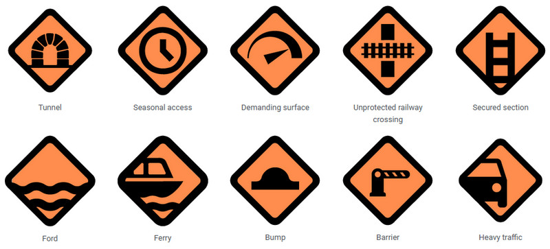
Some warnings have three color-differentiated levels – from the least to the most serious warning:

If a warning concerns entire sections of the route, e.g., challenging surfaces or heavy road traffic, it also has a zonal variant, so you know exactly which part of the route to be careful on.
LoRouter Offline
Available only with Premium Gold
The most sophisticated router of the app. It contains many routing profiles with additional configurations.
Profiles setup

By default, LoRouter Offline offers 8 basic profiles. Each profile has additional setting option:

You can change the profile selection:

Advanced settings - it is also possible to map a custom profile on an existing in-app profile:

- tap an internal profile
- select an external profile from the drop-down menu
- rename the profile (it is not possible to change the icon, though)
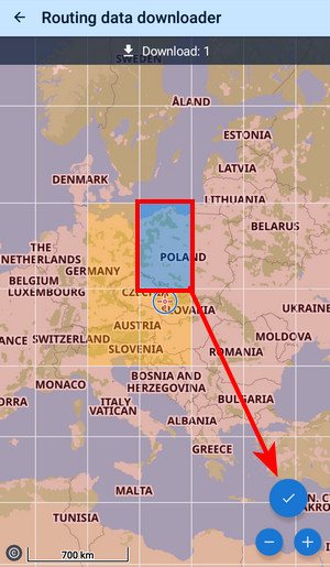
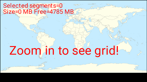
Routing data downloader
You can download offline routing data in advance which we strongly recommend - or you'll be prompted to download them additionally while planning a route.

- select an area from the grid
- confirm download:
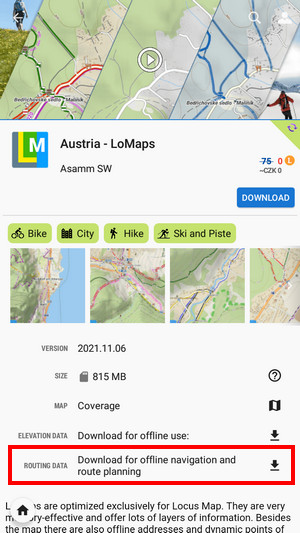
You can download routing data also from Locus Store. Each offline map offers an additional link for download of the data for the area covered by the map:
- open Locus Store
- find a map of the desired area
- download its routing data:
Routing data is automatically updated. You can set the update interval:

External routers
- GraphHopper - very fast and data-efficient routing service. Suitable for all ordinary outdoor activities. It offers three bike profiles: cycle, MTB, and racing, two types of walk profiles: walk and hike and a car navigation profile.
With Premium Gold, GraphHopper can render two routes at once, for each route segment individually:
- BRouter - external offline router - requires the installation of an independent application BRouter and downloading offline navigation data:
- launch BRouter

- select Download manager
- zoom in and select the area you need for offline routing

- Confirm downloading of the selected data file.
BRouter offers many more routing profiles with additional configurations:

You can also change the profile selection:

Advanced settings
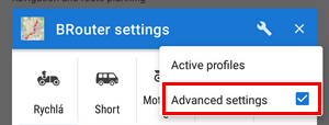 With these, you can link external profiles to the in-app selection:
- tap an in-app profile and select the corresponding external profile from the roll-out selection:

- rename the in-app profile, if necessary
Custom routing profiles
Besides the LoRouter or BRouter profiles embedded directly in Locus, it is also possible to use profiles provided by the BRouter developer or by other users as the .BRF files:
- copy them into /Locus/router/profiles2 directory
- restart the app.
Poutnik's GitHub page provides further information on this as well as many ready-to-use profiles.
Link with presets
Linking with the app presets enables fast re-setting of the whole app after the navigation start so that its preferences are better suitable for navigation. E.g. cursor is shifted, map rotation is on, the screen is turned permanently on etc. Three most used navigation profiles can be linked - walking, biking and motor vehicle:
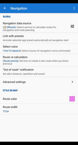
Select voice
- No voice - voice commands are disabled
- Text-to-speech - Android text-to-speech automatic system. TTS is set in Language&Units settings section.
It is possible to download other voice sets from the Locus Store. Warning: using a voice set disables “out of the route” notifications.
Route re-calculation
AUTOMATIC
Available only with Premium
 Navigation route is recalculated automatically if the deviation from the former route is greater than the parameter distance for recalculation. If you don't follow the recalculated route, Locus Map will recalculate it once again after 30 seconds. You will need internet connection in case an online routing service is selected (i.e. LoRouter online or GraphHopper). There are 3 options:
- No auto recalculation - the function is switched OFF - Locus switches to guidance to the nearest point of the original route
- Point priority - Locus recalculates the route to the nearest transit (or 'via') point on the planned route. If there are no 'via' points, it recalculates the route to the final point.
- Route priority - used when you deviate from the original line and want to get back to it - Locus navigates you to the original line from the nearest possible place - the line (route) matters.
MANUAL
Settings for manual recalculation that can be triggered from navigation panel.
Out of route notification
Check this option if you want Locus Map to warn you when you accidentally leave your route. Set the alert distance, alert repetition and type of sound (beep, voice…):

Appearance
Line style

- Basic - in default settings, the line width and color it is optimized for the best visibility. Anyway, it is possible to change them.
- Custom - you can set all parameters of the line style Locus Map offers in its line style editor
- Keep original - when you navigate an already existing route (imported, planned, recorded track…) and you want to maintain its line style during navigation, select this option.
Navigation cursors
Here you can select set of navigation cursors and set their size (50%-400%). You can also add more from Locus Store or add custom icons.
Next turn panel
Select from three options:
- full
- small
- disabled - no turn box is displayed, the direction arrows emerge only on the route line on the map
Stats panel
Here you can switch on or off navigation statistics - ETA, distance to the finish etc.
Street panel
The bar with the street name or road number can be switched on/off here.
Advanced settings
Strict route following
Each route consists of a chain of routepoints (sort of breadcrumbs). This option navigates strictly from one routepoint to another. When you make a deviation, it tries to get you to the last omitted routepoint.
Keep in mind that this feature may come into conflict with your intentions e.g. when making unwanted detour and part of the original route is not accessible - it will keep navigating you to the first missed routepoint. If you want to skip a routepoint, switch it manually to the next nearest point in the Navigation control menu.
This feature does not work when Auto-recalculation with Point priority is ON.
Maximum allowed deviation from the route
Sets maximum allowed deviation from the route before switching navigation to guidance back to the route.
Snap to route
Ignores slight deviations of GPS positioning and maintains the navigation cursor position on the navigated route.
Frequency of commands
Imported routes usually don't contain navigation commands so when you select navigation along such a route, Locus generates the navigation commands according to the shape of the route line. This setting defines how often you are prompted of direction changes on the route: none - low - medium - high.
Two commands at once
When two turns of a route follow closely, Locus Map notifies of both of them at once. Unchecking divides the navigation command into two separate ones.
Line to destination
Shows a dashed line between your current location and the navigation destination for better understanding of the target direction.

Stop navigation at route finish
When checked, the navigation is stopped and navigation panel removed when you get to the finish of your route
manual/user_guide/functions/navigation/settings.1698063293.txt.gz · Last modified: by mstupka
Except where otherwise noted, content on this wiki is licensed under the following license: CC Attribution-Share Alike 4.0 International
