Translated from English by gtranslate.io
Sidebar
manual:user_guide:maps_tools:offsets
Table of Contents

Map Offset
About
For most of you this function will remain unused but there are some countries that corrupt their public maps for whatever reasons, military etc. by offsetting them in unknown directions. There are also some of you who have incorrectly calibrated their map and want to move it temporarily on the correct place. To correct such maps locally there is the offset function that enables to shift the map on two axes.
1. Select maps
Select a map to display (and to offset) in the Maps Manager. If you want to use another map layer to check the offset, use the Map overlays function to define the overlay map and their mutual opacity.
2. Set the map offset
- Tap the function in Menu > All features > Map tools > Map offset. The offset setting window is divided into two parts, Base map and Overlay. The function enables to define offset separately for both active maps:
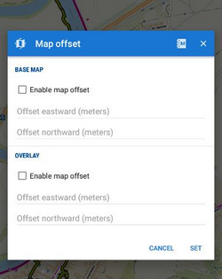
- Check Enable map offset to quickly enable/disable the feature. You may define offset for currently using map and disable it when you use a different map that is correctly placed or calibrated.
- Below are two fields defining offset on X and Y axes. Positive values shift the center eastward (X+) and northward (Y+) - that is the map is moved in opposite direction. Vice versa, the negative values move the center westward and southward.
manual/user_guide/maps_tools/offsets.txt · Last modified: by mstupka
Except where otherwise noted, content on this wiki is licensed under the following license: CC Attribution-Share Alike 4.0 International
