Translated from English by gtranslate.io
Sidebar
manual:advanced:customization:config
This is an old revision of the document!
Table of Contents
Custom settings
Expert settings
This section is IN CONTINUOUS DEVELOPMENT - settings from the Config.cfg file are being moved to a special part of the settings within the app
Settings that are not essential for running the app and overall user experience. Some of these settings were removed from the general settings because of weak usage, some were found redundant and some have a purpose only for advanced Locus Map users.
Activation
- long press Locus main menu button
- tap Expert settings
- Expert settings appear at the bottom of the Locus Map general settings
UI/UX
Confirm on exit
It displays/hides a confirmation dialog when you exit the app by double-tapping the back button.
Full screen
This hides system panels. Originally, in the general settings, it was removed as not all devices support this option correctly.
Quick map switch - online
Sets the number of last used online maps (max 20) displayed in the quick map switch menu in the map content panel.
Quick map switch - offline
Sets the number of the closest offline maps (max 20) displayed in the quick map switch menu in the map content panel.
Auto screen-lock
This activates the Locus Map app's screen lock automatically when you switch the screen off.
Panels visible at start
This displays the function and information panels on the screen after the app's start, despite their “hidden” status.
Display tips&tricks
Displays information boxes in various parts of the app, highlighting key features and usage instructions.
Maps
Hold map center timeout
Defines the period of time in seconds before your location is automatically centered on the map screen in case the Hold map center is active.
Enable GPS when centering
Turns the GPS on automatically (if it is disabled) when you tap the centering button. If turned off, the app centers on your latest fixed location.
Dual centering button
Turns on the default button controlling both map centering and rotation. If turned off, two buttons appear on the screen - one for centering and one for rotating the map.
Smooth movement
Animated movement of the cursor during track recording, resulting in a “smooth” shift of the map. Increases the battery consumption a bit due to the high refresh frequency of the screen.
Map movement step
Defines the map shift step in pixels. Used in case the map is controlled by hardware DPAD buttons.
Fill map gaps with other zooms
Allows the use of lower and higher map zooms to cover empty spaces in an actual map zoom. Useful for various custom raster maps.
Crop maps by coverage
Map content
Settings of auxuliary graphics used on the map screen.
Dynamic elevation, text size, color and background color
Defines style of dynamic elevation digits displayed at the cusor position.
Values above/below 'Cursor to GPS'
Defines parameters displayed above and below the Cursor to position line - distance, bearing, time of arrival, elevation, time to taget and ETA&time to target.
Cursor to GPS line color, background and text size
Definition of the style of Cursor to position line.
Course bearing line color/background
Definition of the style of the Course line
Heading line color/background
Definition of the style of the Heading line
Time rings color, background, text size
Definition of the style of the Time circles
Distance rings color, background, text size
Definition of the style of the Distance circles
Values above/below map lines
Select parameters displayed above an/or below various lines in app - route planner, two-finger measurement etc. - distance, bearing, time of arrival, elevation, time to taget and ETA&time to target.
Tracks
Fill color of chart with...
Custom settings of track/route chart line colors.
Route planner
Route, interpolation step
Definition of distance between interpolated points on route for manual route drawing - affects slope/elevation coloring of the route line. Minimum 1m.
Tools
Hardware buttons when 'screen lock'
When enabled, hardware buttons can control the app even when the screen is locked.
Scroll to zoom
When enabled, it is possible to zoom the map by scrolling controller (e.g. mouse when run on a PC)
Record sensors data
When enabled, all the phone sensors data are recorded in a file in Locus/data/sensors directory.
Enable TTS over BT SCO
When enabled, TTS audio is played over a Bluetooth SCO module.
Tweaks
Smooth interface
Enables animations and other tweaks for more comfortable experience. We recommend to use this only on fast devices.
Allow login over Google Play Services
When switched off, only an e-mail login to Locus Store or Live Tracking is possible. Recommended when MicroG service is used.
 TO BE CONTINUED…
Configuration file
- Since version 2.3.2 Locus Map offers advanced configuration options through config.cfg file stored in Locus Map root directory in your phone memory
- This file is automatically created during Locus Map first start (if it does not exist from its previous installation). Data are loaded at start and stored back to file in the end, so even if this file allows changing some settings that are also changeable in the application, settings will not be lost.
As this method has become obsolete and is quite user unfriendly, settings included in this configuration file are going to be moved gradually to the Expert settings section above.
Examples of some parameters
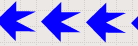
guiding_path_map_symbol
This parameter allows to define very precisely the shape and size of the guiding line. Best is to explain it on the default parameter.
Basic values are: -8.0|-2.0|7.0|0.0|-8.0|2.0
Imagine squared paper. Each two numbers mean X and Y coordinates. So draw them. Result will be as in the picture below. The same way you may draw whatever symbol you want.
![]()
Examples of some settings
guiding_path_symbol
 guiding_path_symbol=-20|0|-20|-10|0|-10|0|-20|20|0|0|20|0|10|-20|10
 guiding_path_symbol=-11|0|-14|-5|5|0|-14|5
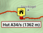
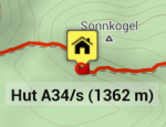
example of transparent label background:
map_items_labels_color_text=#0A0A0A
map_items_labels_color_bg_normal=#4CF0F0F0
map_items_labels_color_border_normal=#19F0F0F0
map_items_labels_color_bg_highlight=#4CF0F0F0
map_items_labels_color_border_highlight=#19F0F0F0
see the difference (default and customized)
manual/advanced/customization/config.1759327938.txt.gz · Last modified: by mstupka
Except where otherwise noted, content on this wiki is licensed under the following license: CC Attribution-Share Alike 4.0 International
