Translated from English by gtranslate.io
Sidebar
manual:user_guide:functions:navigation
Table of Contents

Navigation
Locus Map provides two kinds of navigation:
Navigate to...
Standard turn-by-turn navigation with voice commands from point A to point B with route calculated by a router. Locus Map supports several online routing services and you can of course navigate also offline. The router calculates the route according to selected navigation profile (activity or means of transport) - car, bicycle, foot etc. In case of online routing services it is necessary to be connected to the internet. More info >>
Navigation along a route
Follows user-defined or imported routes. Locus Map renders voice navigation commands automatically from the shape of the route. More info >>
Control Panel
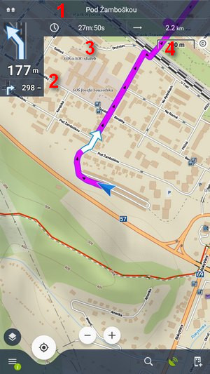 Appears after the start of the navigation. It consists of the street name/road number indicator (1), indicator of the shape and distance of the next two turns (arrow box)(2) and two adjustable fields (3,4) that can display:
- Distance to target (3) (default)
- Time to target (4) (default) - estimated time calculated upon your average speed
- Time of arrival - estimated arrival time calculated upon your average speed
- Time to next junction - time to the next crossroads where the direction will be changed
- Current time - device clock
- Altitude - current altitude of the user, calculated from GPS or the device barometer
- Speed - current speed
In some cases the street name/road number indicator may be empty as the selected router does not have it in its database.
Control Menu
It can be displayed by tapping the arrow box.
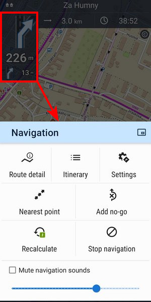
- topbar contains a picture-in-picture mode button. Available on devices with Android 8+:
- Route detail - displays screen with detailed info about the route:
- Itinerary - displays the list of turns along the route
- Settings - link to the general configuration of the navigation
- Nearest point - shifts the map to the nearest route point
- Add no-go - inserts an area to avoid on the place of the map cursor
- Recalculate - manual trigger of route recalculation and indicator of selected navigation profile. Short tap recalculates the route in the selected navigation profile. A long tap opens a menu of other available profiles so the route can be recalculated in a different profile:
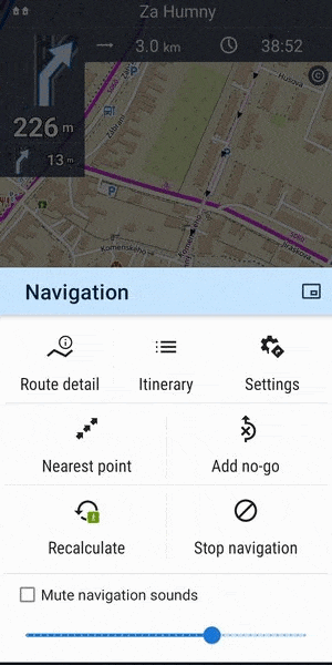
- Stop navigation - stops navigation and deletes the calculated route
- Volume slider and Mute check-button - sets volume of voice commands
Settings
Here you can set the router, voice commands etc. More info >>
Leaving the route
When you are forced to leave navigated route Locus offers several ways how to lead you back on it (or to your target):
Guidance
Locus leads you to the nearest point of the route by a guiding line. It displays also distance to it (and other values if you set them in guidance settings).
Auto recalculation - route priority
Selected routing service recalculates your way back to the nearest place on your original route. This option is recommended for navigation along a route:
More info >>
Auto recalculation - point priority
Selected routing service creates a new route leading to the nearest via point or to the finish of the route. This option is recommended for point-to-point navigation:
More info >>
Notification
Locus can notify you when you leave your navigated route - either by voice (it informs about direction and distance of the nearest route point), by a sound, beep or vibration. More info >>
Adding via points during navigation
You can add a via point to the route when the navigation is in progress:
- Tap the add-to-route icon the bottom menu:
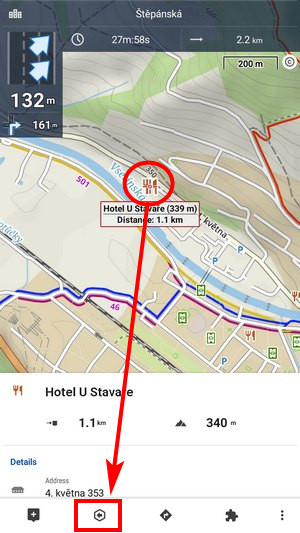
The point is added to the route.
manual/user_guide/functions/navigation.txt · Last modified: by mstupka
Except where otherwise noted, content on this wiki is licensed under the following license: CC Attribution-Share Alike 4.0 International
