Translated from English by gtranslate.io
Sidebar
manual:user_guide:functions:data_import
This is an old revision of the document!
Table of Contents

Data Import
About
- Menu > More > Data Import
Data import is used when you want to work with tracks and points from external sources - websites, file folders, databases, applications, add-ons etc. This function is a general place where to start importing. Otherwise there are many other spots where the import can be launched from, depending on the content you want to import - points or tracks.
Locus Map file manager
When selecting the Data Import function, Locus Map opens a file manager window displaying three tabs where to choose files to import. Importable files are in full color and are clickable. More about supported formats see in points/tracks dedicated import chapters.
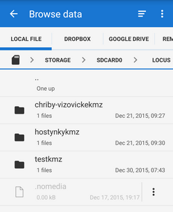
- Local file tab - directory structure of your device memory. Importable files are usually stored in SDCARD folder.
- Dropbox tab - directory structure of your Dropbox folder
- Remote file tab - contains socket for inserting URL of a remote file stored in an Internet repository (Rapidshare, Mega, Mediafire etc.)
Import dialog
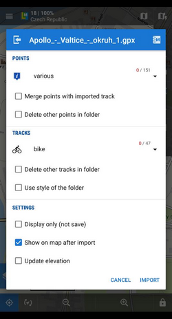
After selecting the file Locus Map analyses it and modifies the import dialog according to the content - the dialog can process points or tracks or both of them at once.
manual/user_guide/functions/data_import.1439807321.txt.gz · Last modified: (external edit)
Except where otherwise noted, content on this wiki is licensed under the following license: CC Attribution-Share Alike 4.0 International
