Translated from English by gtranslate.io
Sidebar
manual:user_guide:tools:altitude
Table of Contents

Altitude Manager
Altitude Manager enables you to fine-tune the altitude values Locus Map receives from your mobile device. It is divided into three main tabs:
- Settings
- Offset
- Pressure
Settings
Contains general switches of offset and pressure sensor and settings of elevation data assistance and altitude measurement filter:
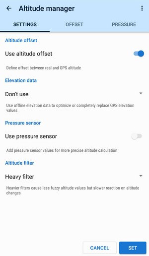
Elevation data
Available only with Premium
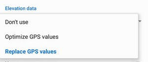
- Don't use - altitude values are acquired from GNSS only (location sensors of your device including data from satellites GPS, Galileo etc…)
- Optimize GPS values - uses offline elevation data to optimize GPS altitude values. Optimized elevation has similar accuracy to an average GPS but does not contain serious errors GPS units usually make. Elevation data can be downloaded several ways.
- Replace GPS values - uses offline elevation data only for displaying elevation and calculating elevation gain and charts
Warning for pilots: optimizing or replacing GPS altitude by elevation data is not recommended for activities when you are not moving on the ground - displayed altitude values are influenced by the ground altitude measuring and calculation
Altitude filter
Applies a filter to altitude measurement to reduce deviations. Heavier filters cause less fuzzy altitude values but slower reactions to altitude changes. The scale ranges from no filtration to an ultra-heavy filter.
Altitude offset
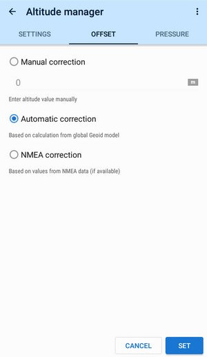 Altitude calculated by internal or external (Bluetooth) GPS unit is related to a different method of referencing the Earth's surface than that used in maps. The difference between them is called Geoid height which is the distance between Geoid and reference elipsoid.
Locus Map can define this offset by three methods:
- Manual correction - the basic method used when the exact offset value is known
- Automatic correction - a method used in most cases - Locus Map can compute the offset of the whole world from a Geoid model. This method is accurate enough for use in mobile phones and sufficiently precise for all locations (the offset slightly varies based on location). Available only with Premium
- NMEA correction - mobile device communicates with GPS unit over special messages called NMEA. These messages contain values of Geoid height that Locus Map can read and apply them to correct this offset.Some devices report incorrect values so this method is unreliable.
Pressure sensor
 Some devices are equipped with a barometric pressure sensor. Barometric sensors measure atmospheric pressure very precisely which can be used for calculating relative altitude changes. I.e. if you know certain pressure at a certain altitude you can calculate altitude changes between the known and current position.
The pressure sensor must be calibrated to a known altitude value so that it can be used for real altitude value calculations. Locus Map offers several methods:
- Automatic - Locus Map uses GPS altitude or elevation files and current barometric pressure as basic values and relates all other measurements to these values. It also checks measured values in 2-hour intervals and eventually re-calibrates the pressure sensor.Available only with Premium
- Pressure - current pressure value at a particular sea level as the reference can be obtained from the Internet. The resulting altitude calculation is also quite accurate but the base pressure changes in time so it can be a problem.
- Altitude - uses some other source of ground altitude - external maps, measuring, tourist guide posts, etc. as the reference. Locus Map then calibrates the pressure sensor according to this value.
Some devices e.g. Samsung Galaxy Note II turn off the pressure sensor in standby mode. If you want to use a pressure sensor during e.g. track recording, make sure your device maintains the pressure sensor on also when the screen goes off.
Altitude measurement workflow
Locus Map applies the above-mentioned computations in the following order:
- received altitude from the GNSS unit
- using elevation data files (if enabled)
- using the pressure sensor
- final filtering
If step 2 is missing, the pressure sensor calibration uses directly received altitude values.
The recommended setup is using elevation data (fully replacing GNSS) without a pressure sensor or using the elevation data only to optimize altitude (useful to eliminate unwanted peaks) + pressure sensor if it's available.
manual/user_guide/tools/altitude.txt · Last modified: by mstupka
Except where otherwise noted, content on this wiki is licensed under the following license: CC Attribution-Share Alike 4.0 International
