Translated from English by gtranslate.io
Sidebar
manual:user_guide:geocaching:import
This is an old revision of the document!
Table of Contents

Import of geocaches
in reconstruction
Before the geocache hunt starts it is necessary to get the geocaches into Locus Map. There are several ways how to do it and some of them need help from external add-ons:
Search and download
Available only with Locus Map Premium
The simplest way how to get geocaches into the app:
- go to the main menu > All features > Geocaching > Geocaching tools > Search for geocaches:
- 1) select the location around which to search the geocaches - the screen center is the default. If you want another, tap the location selector button.
- 2) set the number of geocaches from 10 to 500
- 3) set the geocache filter (optional):
- 4) tap SEARCH
My lists and Pocket Queries
Available only with Locus Map Premium and to Geocaching.com Premium members
About
Pocket Query, also known as “PQ” or just “query”, is a GPX file with geocaches that was rendered at Geocaching.com according to instructions from the user. For example, it is possible to define all geocaches with difficulty grade 3 within a circle of a certain radius around given GPS coordinates.
After a few minutes of processing the created file is available in the tab “Pocket Queries Ready for Download” in the user's Geocaching.com profile or the rendering can be postponed at a particular time in the future.
- Pocket Query can contain <1000 geocaches only.
- Locus Map can also handle .zip files - check this to reduce the query file size.
Download
- from URL at Geocaching.com site or the file can be sent via email directly to the android device
- directly in Locus Map by Geocaching Live:
- Menu > All features > Geocaching > Geocaching tools >
 Load Pocket Queries
Geocaching.com provides a video tutorial about making Pocket Queries:
<html><iframe width=“800” height=“315” src=“https://www.youtube.com/embed/JdUToGF1Kkc” frameborder=“0” allowfullscreen></iframe></html>

Geocaching4Locus Add-on
About
- made by Arcao
Another option that adds more geocache downloading functions into Locus Map.
Setup
- Download and install it from Google Play Store
- Start Geocaching4Locus - Menu > All features > Geocaching > Geocaching4Locus
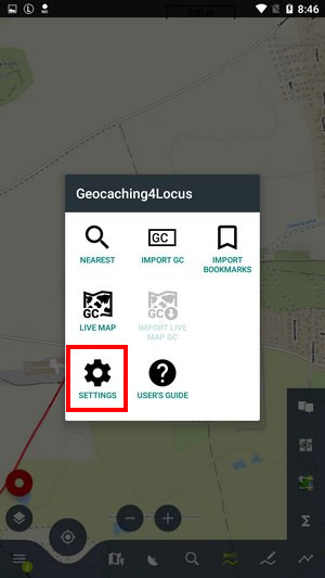
- Geocaching4Locus menu appears, select Settings > Account > Sign in
- Enter your Geocaching.com username and password and confirm
- Authorize Geocaching4Locus by tapping Allow access
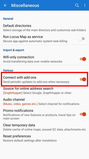
- Make sure that Locus settings > Miscellaneous > Connect with add-ons is turned ON:
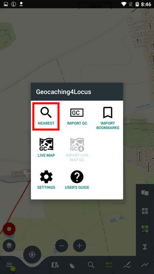
After installation and setup the following options appear across Locus Map:
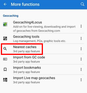
Nearest caches
The option to find the nearest geocaches around a selected location can be found in several places:
- Menu > All features > Geocaching > Nearest caches
Set coords or tap GPS to get your location - Tap any point (user point or LoPoint) on map > detail screen > bottom panel >
 add-on button > nearest caches
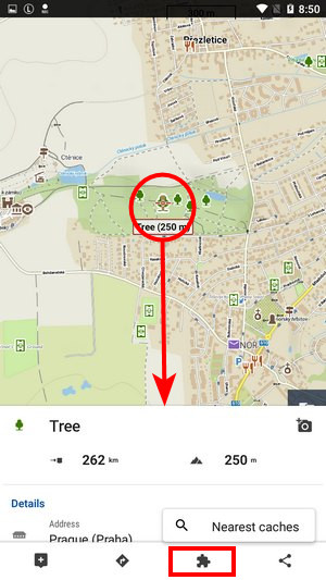
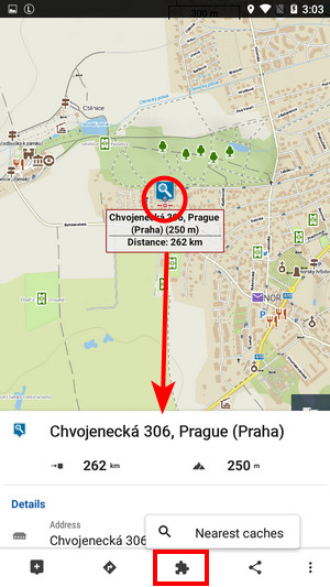
This searches for geocaches nearby the point. - Long-tap any place on map > address detail screen > bottom panel > add-on button > nearest caches - searches for geocaches around the the selected place on the map (the on-screen address search must be enabled):
- in Geocaching4Locus menu:
What to do next:
- set number of geocaches to download and filter of caches (optional)
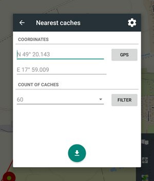
- Tap the download button
- Select a folder for your caches, check Show on the map after import and tap Import. You may need to empty the import folder before downloading caches to save place in your device memory so check the option. Locus Map Premium users may also let Locus update the elevation of the imported caches.
- Geocaches appear on the map.
Basic members are limited to only 3 traditional caches in 24 hours
Live map
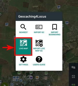
With this feature, the geocaches appear above the map in real-time without import - you have to be online.
- Make sure you have Connect with add-ons setting ON.
- Basic members see traditional caches only.
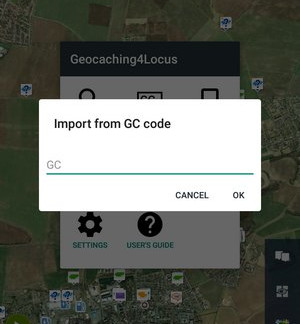
Import GC
Each geocache has its own unique GC code. Use this feature to import a particular geocache by its GC code.
For more information check manual of Geocaching4Locus.
Other third-party add-ons
GSAK for Locus
GSAK is a geocache management program where you can edit the final waypoints, add notes or other auxiliary points, or import/export geocaches.
This add-on provides a link between GSAK where the geocaches are stored and Locus Map. With this add-on, you can view all geocaches, you have stored in GSAK, display their listing, and more. And all this offline without an internet connection.
GeoGet4Locus
The add-on allows you to import caches from db3 files from GeoGet for further work in the Locus Map application. If you use one file, the application will start loading the cache immediately. In the case of multiple files in a folder, the add-on will first offer the option of which file to import.
Cooperating apps
C:GEO
C:geo is an open source, full-featured, always ready-to-go unofficial client for geocaching.com and offers basic support for other geocaching platforms (such as Opencaching).
manual/user_guide/geocaching/import.1670954265.txt.gz · Last modified: by mstupka
Except where otherwise noted, content on this wiki is licensed under the following license: CC Attribution-Share Alike 4.0 International
