Translated from English by gtranslate.io
Sidebar
manual:user_guide:tools:gps
This is an old revision of the document!
Table of Contents

GPS/Compass
The GPS/Compass button/indicator can be placed in one of the Functions panels. It indicates your internal GPS status:
 - acquiring of location is disabled
 - searching for location but valid location not found yet, location on the map is marked by an orange circle
 - the same as above, but Internal GPS Auto-off is enabled (see more in GPS settings >>)
 - current location is valid (GPS is fixed), location on the map is marked by a blue circle
 - the same as above, but Internal GPS Auto-off is enabled (see more in GPS settings >>)
The GPS/Compass button switches on a separate two tabbed window displaying GPS skyplot and Compass. When you hold the GPS/Compass button, a menu appears for a fast switch of GPS status.
GPS
The first displays the skyplot - placement of monitored GPS satellites and other useful information like current altitude, speed, GPS accuracy, current coordinates, number of fixed/visible satellites and time of the last GPS fix.
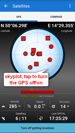
Legend
- Circles - satellites of U.S. Global Positioning System
- Squares - satellites of the Russian Glonass positioning system
- Color - signal quality (red - low, yellow - middle, green - high)
- Height of bars - signal to noise ratio
Tapping the skyplot or the button in the bottom switches GPS on/off.
Compass
The other tab displays the compass, azimuth, distance of your navigation target and tilt of the phone. Lower line contains also fields for time to next waypoint active in navigation and declination value.
The compass ring displays current position of the Sun in the sky .
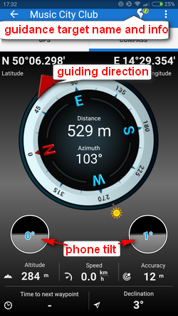
Tapping the tilting indicators opens a menu offering sensor calibration.
![]()
Topbar menu
Contains switches of a few useful functions and settings:
- Use hardware compass - a shortcut to the sensors settings - switches to the built-in hardware compass. Hardware compass bearing is more suitable for slower speeds, e.g. walking, as it does not require movement to detect direction unlike GPS. GPS azimuth bearing is more suitable for car navigation due to magnetic components in the car.
- Bluetooth manager - switches to the settings dialog of connected Bluetooth devices.
- Altitude manager - switches to the altitude settings dialog
- GPS and location - a shortcut to the GPS and location settings
- Sensors - a shortcut to the the sensors settings
- System settings - a shortcut to your device system settings of GPS and location
manual/user_guide/tools/gps.1471252499.txt.gz · Last modified: (external edit)
Except where otherwise noted, content on this wiki is licensed under the following license: CC Attribution-Share Alike 4.0 International
