Translated from English by gtranslate.io
Sidebar
manual:user_guide:maps_locusmaps
Table of Contents

LoMaps
LoMaps are the default maps of the Locus Map app. They are based on OpenStreetMap Data and cover the whole world. They are available both online and offline.
Online LoMap
- it's FREE both in the app and on web.locusmap.app
- there are two types
- hiking and biking map with marked trails
- winter map with ski slopes and Nordic skiing trails
- contains LoPoints - dynamic points of interest based on OSM and Wikipedia
- updated daily
Offline LoMaps
- cover the whole World in map packets covering individual states or their parts, depending on their size
- can be switched into themes: hiking/biking, skiing, town plan, and road map. Each theme is based on the same map data but displays different layers and symbols according to the user's needs.
- contain offline addresses - beginning with LoMaps 2016/04/01- addresses can be searched for
- contain offline LoPoints - dynamic points of interest that can be browsed or selectively displayed
- contain elevation data - Available only with Premium - necessary for terrain shading, route elevation profile rendering etc. It is downloaded separately from the LoMap map data.
- contain routing data - Available only with Premium Gold - necessary for offline route planning with LoRouter. It is downloaded separately from the LoMap map data.
- first three offline LoMaps can be downloaded for FREE
Purchase and download
Offline LoMaps can be purchased in ![]() Locus Store. You can enter it two ways:
Locus Store. You can enter it two ways:
- from the Map Manager - select Offline Maps tab in the Map Manager and tap
 button in the bottom right corner - select
  Download maps
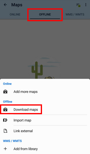
- from the Main Menu - select Locus Store
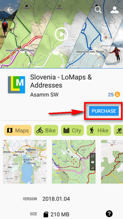
When you find your desired map, tap it to display its detail. You can see the date of the map update on it (offline LoMaps are updated approx. once in two months) and its size in MB before and after unpacking. To start downloading tap PURCHASE or DOWNLOAD.
Purchasing tutorial
First three LoMaps (various ones, not one LoMap + its two updates) are available for free. The “free as a gift” mark is visible in the LoMap detail:
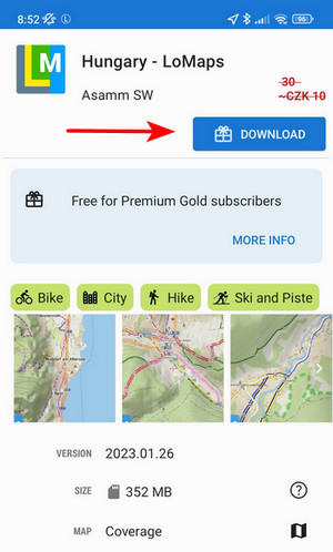
More maps are purchased for LoCoins.
All offline LoMaps are available for FREE with Premium Gold.
Purchased maps appear in Offline maps tab of your Map Manager in folders sorted by country.
Updating
You can download your purchased LoMaps from the server as often as you like for the whole time of its availability. When your LoMap version is no longer available you can download the next oldest available version for free again.
Only if you need the newest LoMap update, you have to buy it. The fee is symbolic, e.g. you can get the whole of California for 0,7 USD.
Examples of LoMap statuses
- LoMap is not purchased
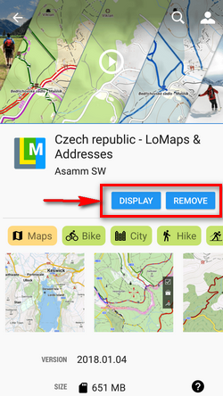
- LoMap is purchased and downloaded, no update is available - you can display the map or remove it from your device memory
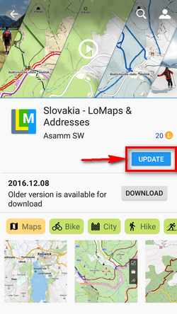
- LoMap update is available - you can purchase the update
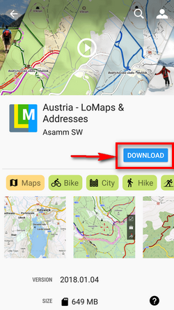
- LoMap is purchased but not downloaded, no update available - you can download your LoMap for free
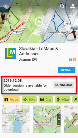
- LoMap is purchased but not downloaded, an update is available too - you can download your LoMap for free or you can purchase the update
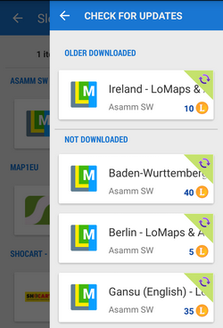
Check for updates
Locus Map does not update your purchased LoMaps automatically, it is always up to you. Check for your updates in Locus Store > User Profile > Check for updates. The updates are divided into two categories:
- older downloaded - purchased LoMaps packages are downloaded but not updated
- not downloaded - purchased LoMaps packages are not downloaded nor updated
Displaying
Downloaded maps are accessible from the Maps Manager, Offline tab. Folders with LoMaps are marked by an L badge:

To open the LoMap, just tap it. If your location is out of the map, confirm its centering:

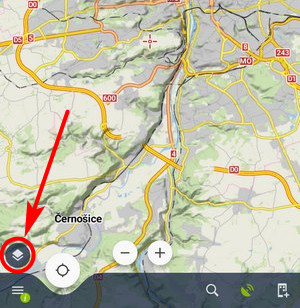
Map menu

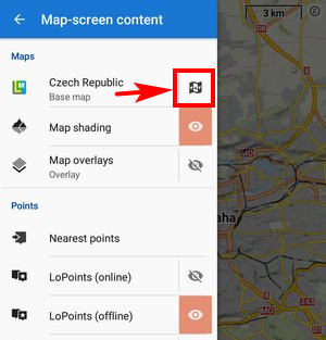
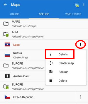
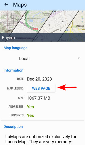
To display the map information window select Details from the map menu:

The window contains a general overview of the map type, map language switch, and the following information:
- Date - date of map data
- Projection - used map projection. Currently, only Mercator projection is allowed
- Created - version of the MapsForge Map Writer plugin used for the map rendering
- Legend - link to the LoMaps legend website
- Size - size in your memory
- Address - Yes/No - data is (not) downloaded
- LoPoints - Yes/No - data is (not) downloaded
- Description - map metadata if there is any, testimonials, etc.
You can create a backup to save the map outside of the Locus Map. Third-party clouds like Dropbox or GDrive are also supported.
To delete the map from the list and your phone, select Delete from the Map menu.
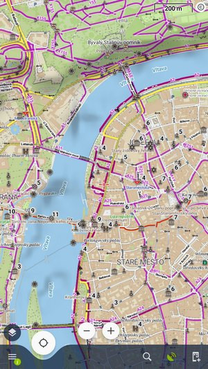
Map themes
LoMaps can be switched into the following themes:
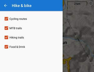
- Hiking&cycling map - contains marked hiking paths, cycling paths, trails, contour lines, guideposts, and a dense network of country roads

- Ski map - includes ski slopes and cross country skiing trails

- City map - general use in cities

- Road map - suitable for driving


Switching map themes
Each vector (or other) map that contains themes or theme layers activates the option to switch these themes. There are a few ways how to do this:
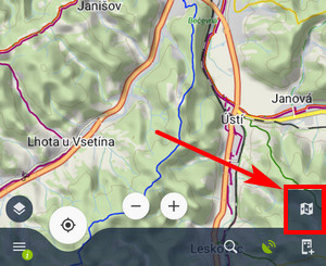
All these methods display the theme menu:
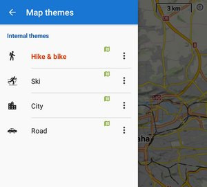
Here you can select the map theme - internal or external (custom). Some themes contain also switchable layers of specific datasets. This way you can fine-tune your map content:
Map language
Names of cities, towns, and villages in exotic destinations can be sometimes difficult to read for Westerners:
 OpenStreetMap data, therefore, contain a transcription of local names in English (or sometimes also in other languages). The language switch can be found in a LoMap detail screen:
 Open the language menu and select the language you understand. Not all names are transcribed, it depends on the activity of the local OSM mapping community. The same map with English-transcribed names
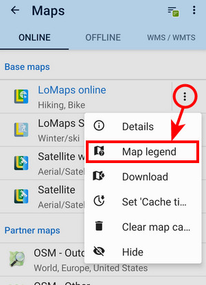
Map legend
The map legend is a list of graphic symbols - lines, polygons and points - used to describe the reality on the map.
It is available within the app both for online:
 and offline LoMap:
manual/user_guide/maps_locusmaps.txt · Last modified: by mstupka
Except where otherwise noted, content on this wiki is licensed under the following license: CC Attribution-Share Alike 4.0 International
